
Mapa topográfico Ax-les-Thermes
Mapa interactivo
Haga clic en el mapa para ver la altitud.
Acerca de este mapa
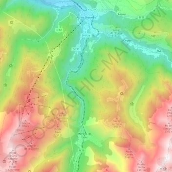
Nombre: Mapa topográfico Ax-les-Thermes, altitud, relieve.
Altitud media: 1.449 m
Altitud mínima: 665 m
Altitud máxima: 2.473 m
Ax (from Latin Aquae – water; French Thermes – hot springs), situated at an elevation of 700 metres (2,300 ft), is well known for its sulphurous hot springs (25 to 78 °C or 77 to 172 °F). The waters, which were used by the Romans, were historically claimed to treat rheumatism, skin diseases, and other maladies. The springs were developed in the medieval period on the orders of Saint Louis to treat soldiers returning from the Crusades afflicted with leprosy. From the 19th century, a spa tourism industry developed.
Otros mapas topográficos
Haga clic en un mapa para ver su topografía, su altitud y su relieve.
Rufat
France > Occitania > Ariège > Ax-les-Thermes
Rufat, Ax-les-Thermes, Foix, Ariège, Occitania, Metropolitan France, 09110, France
Altitud media: 994 m