
Mapa topográfico Highworth
Haga clic en el mapa para ver la altitud.
Acerca de este mapa
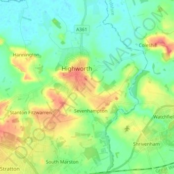
Nombre: Mapa topográfico Highworth, altitud, relieve.
Lugar: Highworth, Swindon, England, United Kingdom (51.58439 -1.74025 51.66311 -1.65997)
Altitud media: 97 m
Altitud mínima: 73 m
Altitud máxima: 146 m
Otros mapas topográficos
Haga clic en un mapa para ver su topografía, su altitud y su relieve.
Swindon
United Kingdom > England > Swindon
Swindon has an oceanic climate (Cfb in the Köppen climate classification), like the vast majority of the British Isles, with cool winters and warm summers. The nearest official weather station is RAF Lyneham, about 10 miles (16 km) west southwest of Swindon town centre. The weather station's elevation is 145…
Altitud media: 108 m