
Haz una donación
Equípate para tu próxima aventura:
Como asociado de Amazon, este sitio gana comisiones por las compras que califican, sin ningún costo adicional para usted.
Mapa topográfico Myrtle Beach
Haga clic en el mapa para ver la altitud.
Haz una donación
Equípate para tu próxima aventura:
Como asociado de Amazon, este sitio gana comisiones por las compras que califican, sin ningún costo adicional para usted.
Myrtle Beach
Myrtle Beach features a predominantly flat topography characterized by its coastal plain setting. The area is situated just a few feet above sea level, with an average elevation of approximately 20 feet (6 meters), making it ideal for expansive sandy beaches and shallow tidal estuaries. The region is part of a continuous stretch of shoreline known as the Grand Strand, which spans about 60 miles (97 kilometers). This topography includes barrier islands and wetlands, providing a diverse habitat for various wildlife. The landscape is largely influenced by the Atlantic Ocean, with numerous inlets and swashes, like Wither's Swash, that define the coastal terrain.
Haz una donación
Equípate para tu próxima aventura:
Como asociado de Amazon, este sitio gana comisiones por las compras que califican, sin ningún costo adicional para usted.
Acerca de este mapa
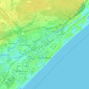
Nombre: Mapa topográfico Myrtle Beach, altitud, relieve.
Lugar: Myrtle Beach, Horry County, South Carolina, United States (33.64738 -78.97802 33.79126 -78.78547)
Altitud media: 6 m
Altitud mínima: -5 m
Altitud máxima: 16 m
Haz una donación
Equípate para tu próxima aventura:
Como asociado de Amazon, este sitio gana comisiones por las compras que califican, sin ningún costo adicional para usted.
Otros mapas topográficos
Haga clic en un mapa para ver su topografía, su altitud y su relieve.
Haz una donación
Equípate para tu próxima aventura:
Como asociado de Amazon, este sitio gana comisiones por las compras que califican, sin ningún costo adicional para usted.
Windy Hill Beach
United States > South Carolina > Horry County > North Myrtle Beach
Altitud media: 2 m
Cherry Grove Beach
United States > South Carolina > Horry County > North Myrtle Beach
Altitud media: 1 m
Ingram Beach
United States > South Carolina > Horry County > North Myrtle Beach > Ocean Drive Beach
Altitud media: 2 m
Haz una donación
Equípate para tu próxima aventura:
Como asociado de Amazon, este sitio gana comisiones por las compras que califican, sin ningún costo adicional para usted.
Cherry Grove Beach
United States > South Carolina > Horry County > North Myrtle Beach
Altitud media: 1 m
Haz una donación
Equípate para tu próxima aventura:
Como asociado de Amazon, este sitio gana comisiones por las compras que califican, sin ningún costo adicional para usted.
Haz una donación
Equípate para tu próxima aventura:
Como asociado de Amazon, este sitio gana comisiones por las compras que califican, sin ningún costo adicional para usted.
Market Common District
United States > South Carolina > Horry County > Myrtle Beach
Altitud media: 5 m
Seabrook Plantation
United States > South Carolina > Horry County > North Myrtle Beach
Altitud media: 3 m
Haz una donación
Equípate para tu próxima aventura:
Como asociado de Amazon, este sitio gana comisiones por las compras que califican, sin ningún costo adicional para usted.