
Mapa topográfico Pindus
Mapa interactivo
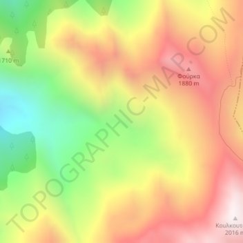
Haga clic en el mapa para ver la altitud.
Acerca de este mapa
Nombre: Mapa topográfico Pindus, altitud, relieve.
Altitud media: 1.510 m
Altitud mínima: 942 m
Altitud máxima: 2.013 m
Otros mapas topográficos
Haga clic en un mapa para ver su topografía, su altitud y su relieve.
Dytiki Soufla
Greece > Thessaly - Central Greece
Dytiki Soufla, Δήμος Δωρίδος, Regional Unit of Phocis, Region of Central Greece, Thessaly - Central Greece, 33052, Greece
Altitud media: 1.893 m
Lafina
Greece > Thessaly - Central Greece > Lafina
Lafina, Pyli Municipality, Regional Unit of Trikala, Region of Thessaly, Thessaly - Central Greece, 42037, Greece
Altitud media: 926 m
Dytiki Frangista
Greece > Thessaly - Central Greece > Dytiki Frangista
Dytiki Frangista, Δήμος Αγράφων, Regional Unit of Evrytania, Region of Central Greece, Thessaly - Central Greece, 36071, Greece
Altitud media: 760 m