
Mapa topográfico Levoča
Mapa interactivo
Haga clic en el mapa para ver la altitud.
Acerca de este mapa
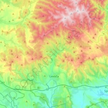
Nombre: Mapa topográfico Levoča, altitud, relieve.
Altitud media: 745 m
Altitud mínima: 425 m
Altitud máxima: 1.238 m
The economic importance of the town was further diminished in 1871 when the important new Košice–Bohumín Railway was built just 8 km (5.0 mi) to the south, bypassing Levoča and going through the nearby town of Spišská Nová Ves. Later, in 1892, only a spur line was built from Spišská Nová Ves railway station to Levoča. Erwin Raisz, a famed cartographer who immigrated to the United States after earning a degree in engineering and architecture from the University of Hungary and after serving in WWI, was born in Levoča in 1893. Raisz learned about map making from his father, also a civil engineer, and was no doubt inspired by the topography of his homeland to create a unique hand-drawn method of portraying physiographic features. He taught at Harvard University and wrote the first cartography textbook in English.
Otros mapas topográficos
Haga clic en un mapa para ver su topografía, su altitud y su relieve.
Spišské Podhradie
Slovakia > Region of Prešov > District of Levoča
Spišské Podhradie, District of Levoča, Region of Prešov, Eastern Slovakia, 053 04, Slovakia
Altitud media: 574 m