Geolocalizar

Mapa topográfico Titsey

Haga clic en el mapa para ver la altitud.

Acerca de este mapa

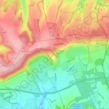
Nombre: Mapa topográfico Titsey, altitud, relieve.

Lugar: Titsey, Tandridge, Surrey, England, United Kingdom (51.26238 -0.01728 51.29960 0.04088)

Altitud media: 185 m

Altitud mínima: 100 m

Altitud máxima: 271 m

Otros mapas topográficos

Haga clic en un mapa para ver su topografía, su altitud y su relieve.

Caterham

United Kingdom > England > Surrey > Tandridge

In 1840 Caterham contained a total of 477 residents (figures taken from that census, compiled in an 1848 topographical encyclopedia) and in 1848 468 acres (189 ha) of its 2,386 acres (966 ha) were common land. Similar to today, 175 acres (71 ha) mostly steeper acres were woodland.

Altitud media: 157 m

New Chapel

United Kingdom > England > Surrey > Tandridge

Altitud media: 64 m

Botley Hill

United Kingdom > England > Surrey > Tandridge

Botley Hill is a Marilyn (a hill with topographic prominence of at least 150m), and the third highest point in the county (after the peaks of Leith Hill south of Dorking and Gibbet Hill in Hindhead, both on the Greensand Ridge).

Altitud media: 206 m

Caterham

United Kingdom > England > Surrey > Tandridge

In 1840 Caterham contained a total of 477 residents (figures taken from that census, compiled in an 1848 topographical encyclopedia) and in 1848 468 acres (189 ha) of its 2,386 acres (966 ha) were common land. Similar to today, 175 acres (71 ha) mostly steeper acres were woodland.

Altitud media: 157 m

Equípate para tu próxima aventura:

📦Bolsas estancas - Protección impermeable para equipo
🗺️Fundas Portamapas Estancas - Lee tus mapas bajo la lluvia sin dañarlos
🎿Raquetas de Nieve - Explora los mapas nevados sin hundirte
🧱Fundas impermeables móvil - Protección del smartphone
👟Sandalias de Trekking Hombre - Calzado ventilado para rutas con cruce de ríos

Como asociado de Amazon, este sitio gana comisiones por las compras que califican, sin ningún costo adicional para usted.