
Haz una donación
Equípate para tu próxima aventura:
Como asociado de Amazon, este sitio gana comisiones por las compras que califican, sin ningún costo adicional para usted.
Mapa topográfico Emalahleni Local Municipality
Haga clic en el mapa para ver la altitud.
Haz una donación
Equípate para tu próxima aventura:
Como asociado de Amazon, este sitio gana comisiones por las compras que califican, sin ningún costo adicional para usted.
Acerca de este mapa
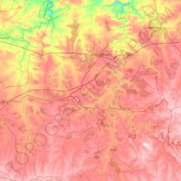
Nombre: Mapa topográfico Emalahleni Local Municipality, altitud, relieve.
Altitud media: 1.545 m
Altitud mínima: 1.266 m
Altitud máxima: 1.745 m
Haz una donación
Equípate para tu próxima aventura:
Como asociado de Amazon, este sitio gana comisiones por las compras que califican, sin ningún costo adicional para usted.
Otros mapas topográficos
Haga clic en un mapa para ver su topografía, su altitud y su relieve.
Middelburg
South Africa > Mpumalanga > Nkangala > Steve Tshwete Local Municipality
Altitud media: 1.493 m
Kriel
South Africa > Mpumalanga > Nkangala > Emalahleni Local Municipality
Hot summers and very cold winters. Rainfall approximately 660 mm per annum. Altitude 1598 m above sea level.
Altitud media: 1.569 m
Haz una donación
Equípate para tu próxima aventura:
Como asociado de Amazon, este sitio gana comisiones por las compras que califican, sin ningún costo adicional para usted.
KwaMhlanga
South Africa > Mpumalanga > Nkangala > Thembisile Hani Local Municipality
Altitud media: 1.338 m
Dullstroom
South Africa > Mpumalanga > Nkangala > Emakhazeni Local Municipality
Due to its high elevation (Dullstroom being the highest town in South Africa itself), Dullstroom has a subtropical highland climate (Köppen: Cwb). From October to April, the town sees a significant amount of rainfall (higher than nearby Johannesburg to the west), in contrast with winter, where precipitation…
Altitud media: 2.009 m
Middelburg Dam
South Africa > Mpumalanga > Nkangala > Steve Tshwete Local Municipality
Altitud media: 1.543 m
KwaMhlanga
South Africa > Mpumalanga > Nkangala > Thembisile Hani Local Municipality
Altitud media: 1.338 m
Haz una donación
Equípate para tu próxima aventura:
Como asociado de Amazon, este sitio gana comisiones por las compras que califican, sin ningún costo adicional para usted.
KwaMhlanga
South Africa > Mpumalanga > Nkangala > Thembisile Hani Local Municipality
Altitud media: 1.338 m
Loskop Dam
South Africa > Mpumalanga > Nkangala > Steve Tshwete Local Municipality
Altitud media: 1.211 m
Verena
South Africa > Mpumalanga > Nkangala > Thembisile Hani Local Municipality
Altitud media: 1.375 m
Hendrina
South Africa > Mpumalanga > Nkangala > Steve Tshwete Local Municipality
Altitud media: 1.672 m
Haz una donación
Equípate para tu próxima aventura:
Como asociado de Amazon, este sitio gana comisiones por las compras que califican, sin ningún costo adicional para usted.
Waterval Boven
South Africa > Mpumalanga > Nkangala > Emakhazeni Local Municipality
Altitud media: 1.547 m
Machadodorp
South Africa > Mpumalanga > Nkangala > Emakhazeni Local Municipality
Altitud media: 1.591 m
Haz una donación
Equípate para tu próxima aventura:
Como asociado de Amazon, este sitio gana comisiones por las compras que califican, sin ningún costo adicional para usted.
Magareng
South Africa > Mpumalanga > Nkangala > Dr JS Moroka Local Municipality
Altitud media: 1.020 m
Rietfontein Dam
South Africa > Mpumalanga > Nkangala > Emalahleni Local Municipality
Altitud media: 1.567 m
Kranspoort Dam
South Africa > Mpumalanga > Nkangala > Steve Tshwete Local Municipality
Altitud media: 1.095 m
Haz una donación
Equípate para tu próxima aventura:
Como asociado de Amazon, este sitio gana comisiones por las compras que califican, sin ningún costo adicional para usted.
Haz una donación
Equípate para tu próxima aventura:
Como asociado de Amazon, este sitio gana comisiones por las compras que califican, sin ningún costo adicional para usted.
Dullstroom
South Africa > Mpumalanga > Nkangala > Emakhazeni Local Municipality
Due to its high elevation (Dullstroom being the highest town in South Africa itself), Dullstroom has a subtropical highland climate (Köppen: Cwb). From October to April, the town sees a significant amount of rainfall (higher than nearby Johannesburg to the west), in contrast with winter, where precipitation…
Altitud media: 2.009 m
Middelburg
South Africa > Mpumalanga > Nkangala > Steve Tshwete Local Municipality
Altitud media: 1.493 m
eMakhazeni (Belfast)
South Africa > Mpumalanga > Nkangala > Emakhazeni Local Municipality
Altitud media: 1.890 m
Haz una donación
Equípate para tu próxima aventura:
Como asociado de Amazon, este sitio gana comisiones por las compras que califican, sin ningún costo adicional para usted.
Dullstroom
South Africa > Mpumalanga > Nkangala > Emakhazeni Local Municipality
Due to its high elevation (Dullstroom being the highest town in South Africa itself), Dullstroom has a subtropical highland climate (Köppen: Cwb). From October to April, the town sees a significant amount of rainfall (higher than nearby Johannesburg to the west), in contrast with winter, where precipitation…
Altitud media: 2.009 m
Emgwenya (Waterval Boven)
South Africa > Mpumalanga > Nkangala > Emakhazeni Local Municipality
Altitud media: 1.424 m
Middelburg
South Africa > Mpumalanga > Nkangala > Steve Tshwete Local Municipality
Altitud media: 1.493 m
Haz una donación
Equípate para tu próxima aventura:
Como asociado de Amazon, este sitio gana comisiones por las compras que califican, sin ningún costo adicional para usted.
Middelburg
South Africa > Mpumalanga > Nkangala > Steve Tshwete Local Municipality
Altitud media: 1.493 m
Dullstroom
South Africa > Mpumalanga > Nkangala > Emakhazeni Local Municipality
Due to its high elevation (Dullstroom being the highest town in South Africa itself), Dullstroom has a subtropical highland climate (Köppen: Cwb). From October to April, the town sees a significant amount of rainfall (higher than nearby Johannesburg to the west), in contrast with winter, where precipitation…
Altitud media: 2.009 m
Machadodorp
South Africa > Mpumalanga > Nkangala > Emakhazeni Local Municipality
Altitud media: 1.591 m
eMakhazeni (Belfast)
South Africa > Mpumalanga > Nkangala > Emakhazeni Local Municipality
Altitud media: 1.890 m
Haz una donación
Equípate para tu próxima aventura:
Como asociado de Amazon, este sitio gana comisiones por las compras que califican, sin ningún costo adicional para usted.
Dullstroom
South Africa > Mpumalanga > Nkangala > Emakhazeni Local Municipality
Due to its high elevation (Dullstroom being the highest town in South Africa itself), Dullstroom has a subtropical highland climate (Köppen: Cwb). From October to April, the town sees a significant amount of rainfall (higher than nearby Johannesburg to the west), in contrast with winter, where precipitation…
Altitud media: 2.009 m
Waterval Boven
South Africa > Mpumalanga > Nkangala > Emakhazeni Local Municipality
Altitud media: 1.547 m
Leratong Stream
South Africa > Mpumalanga > Nkangala > Thembisile Hani Local Municipality > KwaMhlanga
Altitud media: 1.309 m