Geolocalizar
👉 Easily get elevation data in JSON, GeoTIFF and KML formats using Elevation API
Gracias por apoyar a este sitio ❤️
Haz una donación

Mapa topográfico Mainland

Haga clic en el mapa para ver la altitud.

Acerca de este mapa

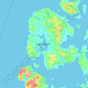
Nombre: Mapa topográfico Mainland, altitud, relieve.

Lugar: Mainland, Orkney Islands, Scotland, United Kingdom (58.87183 -3.36802 59.15495 -2.70337)

Altitud media: 28 m

Altitud mínima: -1 m

Altitud máxima: 478 m

Otros mapas topográficos

Haga clic en un mapa para ver su topografía, su altitud y su relieve.

Orphir

United Kingdom > Scotland > Orkney Islands

Altitud media: 64 m

Lyness

United Kingdom > Scotland > Orkney Islands

Altitud media: 28 m

Midbea

United Kingdom > Scotland > Orkney Islands

Altitud media: 25 m

Hoxa

United Kingdom > Scotland > Orkney Islands

Altitud media: 6 m

Twatt

United Kingdom > Scotland > Orkney Islands

Altitud media: 33 m

Harray

United Kingdom > Scotland > Orkney Islands

Altitud media: 29 m

Ward Hill

United Kingdom > Scotland > Orkney Islands

Ward Hill is a hill on the island of Hoy in Orkney, Scotland. It lies at the north of the island between Moaness and Rackwick, and is the highest point in both Orkney and the Scottish Northern Isles at an elevation of 481 m (1,578 ft).

Altitud media: 194 m

Evie

United Kingdom > Scotland > Orkney Islands

Altitud media: 53 m

Lyness

United Kingdom > Scotland > Orkney Islands

Altitud media: 28 m

Orphir

United Kingdom > Scotland > Orkney Islands

Altitud media: 64 m

Equípate para tu próxima aventura:

🦯Bastones de senderismo - Bastones ajustables para estabilidad en ruta
🪓Piolets de senderismo - Apoyo en terreno nevado
🧥Forros polares - Aislamiento térmico ligero
🧊Neveras Portátiles Flexibles - Mantiene tus alimentos frescos en el coche
📦Bolsas estancas - Protección impermeable para equipo

Como asociado de Amazon, este sitio gana comisiones por las compras que califican, sin ningún costo adicional para usted.