
Haz una donación
Equípate para tu próxima aventura:
Como asociado de Amazon, este sitio gana comisiones por las compras que califican, sin ningún costo adicional para usted.
Mapa topográfico Still Creek
Haga clic en el mapa para ver la altitud.
Haz una donación
Equípate para tu próxima aventura:
Como asociado de Amazon, este sitio gana comisiones por las compras que califican, sin ningún costo adicional para usted.
Acerca de este mapa
Nombre: Mapa topográfico Still Creek, altitud, relieve.
Altitud media: 65 m
Altitud mínima: 18 m
Altitud máxima: 119 m
Haz una donación
Equípate para tu próxima aventura:
Como asociado de Amazon, este sitio gana comisiones por las compras que califican, sin ningún costo adicional para usted.
Otros mapas topográficos
Haga clic en un mapa para ver su topografía, su altitud y su relieve.
West End
Canada > British Columbia > Metro Vancouver Regional District > Vancouver
Altitud media: 15 m
Victoria-Fraserview
Canada > British Columbia > Metro Vancouver Regional District > Vancouver
Altitud media: 67 m
English Bay
Canada > British Columbia > Metro Vancouver Regional District > Vancouver
Altitud media: 7 m
Haz una donación
Equípate para tu próxima aventura:
Como asociado de Amazon, este sitio gana comisiones por las compras que califican, sin ningún costo adicional para usted.
Vancouver East
Canada > British Columbia > Metro Vancouver Regional District > Vancouver
Altitud media: 25 m
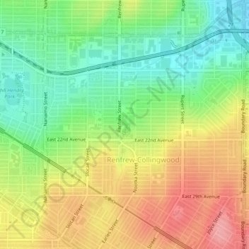
Renfrew-Collingwood
Canada > British Columbia > Metro Vancouver Regional District > Vancouver
Altitud media: 72 m
Cypress Pond
Canada > British Columbia > Metro Vancouver Regional District > Vancouver
Altitud media: 86 m
Little Mountain
Canada > British Columbia > Metro Vancouver Regional District > Vancouver
Little Mountain, elevation 125 m (410 ft), is a mountain in the central part of the city of Vancouver, British Columbia, Canada. The mountain is home to Queen Elizabeth Park, which sits at the top of the mountain, and Nat Bailey Stadium, which is located near the base. The mountain lends its name to the Riley…
Altitud media: 81 m
Haz una donación
Equípate para tu próxima aventura:
Como asociado de Amazon, este sitio gana comisiones por las compras que califican, sin ningún costo adicional para usted.
Riley Park
Canada > British Columbia > Metro Vancouver Regional District > Vancouver
Altitud media: 75 m
Arbutus-Ridge
Canada > British Columbia > Metro Vancouver Regional District > Vancouver
Altitud media: 60 m
Downtown
Canada > British Columbia > Metro Vancouver Regional District > Vancouver
Altitud media: 14 m
Fairview
Canada > British Columbia > Metro Vancouver Regional District > Vancouver
Altitud media: 31 m
Haz una donación
Equípate para tu próxima aventura:
Como asociado de Amazon, este sitio gana comisiones por las compras que califican, sin ningún costo adicional para usted.
False Creek
Canada > British Columbia > Metro Vancouver Regional District > Vancouver
Altitud media: 18 m
Killarney
Canada > British Columbia > Metro Vancouver Regional District > Vancouver
Altitud media: 73 m
Kerrisdale
Canada > British Columbia > Metro Vancouver Regional District > Vancouver
Altitud media: 39 m
Kitsilano
Canada > British Columbia > Metro Vancouver Regional District > Vancouver
Altitud media: 24 m
Haz una donación
Equípate para tu próxima aventura:
Como asociado de Amazon, este sitio gana comisiones por las compras que califican, sin ningún costo adicional para usted.
Dunbar-Southlands
Canada > British Columbia > Metro Vancouver Regional District > Vancouver
Altitud media: 43 m
Granville Island
Canada > British Columbia > Metro Vancouver Regional District > Vancouver
Altitud media: 25 m
Grandview-Woodland
Canada > British Columbia > Metro Vancouver Regional District > Vancouver
Altitud media: 28 m
Kensington-Cedar Cottage
Canada > British Columbia > Metro Vancouver Regional District > Vancouver
Altitud media: 64 m
Haz una donación
Equípate para tu próxima aventura:
Como asociado de Amazon, este sitio gana comisiones por las compras que califican, sin ningún costo adicional para usted.
Mount Pleasant
Canada > British Columbia > Metro Vancouver Regional District > Vancouver
Altitud media: 28 m
Hastings-Sunrise
Canada > British Columbia > Metro Vancouver Regional District > Vancouver
Altitud media: 40 m
Strathcona
Canada > British Columbia > Metro Vancouver Regional District > Vancouver
Altitud media: 10 m
Haz una donación
Equípate para tu próxima aventura:
Como asociado de Amazon, este sitio gana comisiones por las compras que califican, sin ningún costo adicional para usted.
Kitsilano 6
Canada > British Columbia > Metro Vancouver Regional District > Vancouver
Altitud media: 22 m
Kitsilano
Canada > British Columbia > Metro Vancouver Regional District > Vancouver
Altitud media: 24 m
Fairview
Canada > British Columbia > Metro Vancouver Regional District > Vancouver
Altitud media: 31 m