
Haz una donación
Equípate para tu próxima aventura:
Como asociado de Amazon, este sitio gana comisiones por las compras que califican, sin ningún costo adicional para usted.
Mapa topográfico Maryborough
Haga clic en el mapa para ver la altitud.
Haz una donación
Equípate para tu próxima aventura:
Como asociado de Amazon, este sitio gana comisiones por las compras que califican, sin ningún costo adicional para usted.
Maryborough
Maryborough enjoys a temperate climate with four distinct seasons and is typically dry and mild. The mean minimum January temperature 12.9 °C (55.2 °F) with the maximum a balmy 28.8 °C (83.8 °F), however temperatures above 35 °C (95 °F) are commonly recorded during the summer months. The highest temperature ever recorded was 45.4 °C (113.7 °F) on 7 February 2009. The mean minimum temperature in July is 3.4 °C (38.1 °F), with and average maximum of 12.2 °C (54.0 °F). The lowest ever recorded minimum in the city was −4.6 °C (23.7 °F) on 21 July 1982. Although the city experiences little snow due to its low elevation, frosts are common during the colder winter months.
Haz una donación
Equípate para tu próxima aventura:
Como asociado de Amazon, este sitio gana comisiones por las compras que califican, sin ningún costo adicional para usted.
Acerca de este mapa
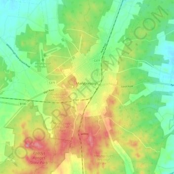
Nombre: Mapa topográfico Maryborough, altitud, relieve.
Altitud media: 238 m
Altitud mínima: 194 m
Altitud máxima: 300 m
Haz una donación
Equípate para tu próxima aventura:
Como asociado de Amazon, este sitio gana comisiones por las compras que califican, sin ningún costo adicional para usted.