
Mapa topográfico Scofield Reservoir
Mapa interactivo
Haga clic en el mapa para ver la altitud.
Acerca de este mapa
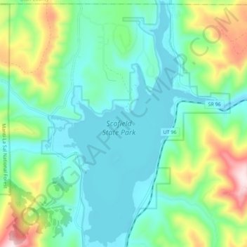
Nombre: Mapa topográfico Scofield Reservoir, altitud, relieve.
Lugar: Scofield Reservoir, Carbon County, Utah, United States (39.74814 -111.17269 39.81400 -111.11997)
Altitud media: 2.435 m
Altitud mínima: 2.307 m
Altitud máxima: 2.804 m
Scofield Reservoir is a 2,815-acre (11.39 km2) reservoir impounded by Scofield Dam, in Carbon County, Utah. Located on the Price River, a tributary of the Green River, Scofield Reservoir is adjacent to northernmost boundary of the Manti–La Sal National Forest. The reservoir sits at an elevation of 7,618 feet (2,322 m), on the northern edge of the Wasatch Plateau. Utah State Route 96 runs along the western shoreline.
Otros mapas topográficos
Haga clic en un mapa para ver su topografía, su altitud y su relieve.
Carbonville
United States > Utah > Carbon County
Carbonville, Carbon County, Utah, 84591, United States
Altitud media: 1.741 m
Clear Creek
United States > Utah > Carbon County
Clear Creek, Carbon County, Utah, United States
Altitud media: 2.726 m
Helper
United States > Utah > Carbon County
Helper, Carbon County, Utah, United States
Altitud media: 1.912 m
Price
United States > Utah > Carbon County
Price, Carbon County, Utah, 84591, United States
Altitud media: 1.711 m
Price
United States > Utah > Carbon County > Price > Price
Price, Carbon County, Utah, 84501, United States
Altitud media: 1.728 m
Scofield
United States > Utah > Carbon County
Scofield, Carbon County, Utah, United States
Altitud media: 2.499 m