
Haz una donación
Equípate para tu próxima aventura:
Como asociado de Amazon, este sitio gana comisiones por las compras que califican, sin ningún costo adicional para usted.
Mapa topográfico Eagle Mountain
Haga clic en el mapa para ver la altitud.
Haz una donación
Equípate para tu próxima aventura:
Como asociado de Amazon, este sitio gana comisiones por las compras que califican, sin ningún costo adicional para usted.
Eagle Mountain
Eagle Mountain is only about 12 miles (19 km) from Minnesota's lowest elevation, Lake Superior, at 600 feet (183 m). It is part of the Canadian Shield. There is also another much shorter peak also named Eagle Mountain in northern Minnesota. The shorter peak is part of the Lutsen Mountains ski resort.
Haz una donación
Equípate para tu próxima aventura:
Como asociado de Amazon, este sitio gana comisiones por las compras que califican, sin ningún costo adicional para usted.
Acerca de este mapa
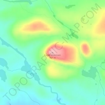
Nombre: Mapa topográfico Eagle Mountain, altitud, relieve.
Altitud media: 596 m
Altitud mínima: 545 m
Altitud máxima: 697 m
Haz una donación
Equípate para tu próxima aventura:
Como asociado de Amazon, este sitio gana comisiones por las compras que califican, sin ningún costo adicional para usted.
Otros mapas topográficos
Haga clic en un mapa para ver su topografía, su altitud y su relieve.
Brule Lake
United States > Minnesota > Cook County > West Cook
Brule Lake lies in a region which has seen human population since the end of the last ice age. It has variously been within the territory of the Dakota, Cree, Ojibwa, French, British, and Americans. It saw little development until the opening of a railroad that allowed loggers easier access to the interior of…
Altitud media: 579 m