Geolocalizar

Mapa topográfico Cold Fell

Haga clic en el mapa para ver la altitud.

Acerca de este mapa

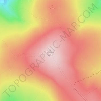
Nombre: Mapa topográfico Cold Fell, altitud, relieve.

Lugar: Cold Fell, Carlisle, Cumbria, North West England, England, CA8 2PN, United Kingdom (54.89384 -2.61631 54.89394 -2.61621)

Altitud media: 517 m

Altitud mínima: 296 m

Altitud máxima: 620 m

Otros mapas topográficos

Haga clic en un mapa para ver su topografía, su altitud y su relieve.

Dalston

United Kingdom > England > Cumbria > Carlisle

Altitud media: 90 m

Farlam

United Kingdom > England > Cumbria > Carlisle

Farlam was originally divided into two townships, East Farlam and West Farlam, with a combined population in 1811 of 672 inhabitants and 115 houses. Hallbankgate and Kirkhouse were two hamlets located within the township of East Farlam, the former four miles south east of Brampton, and the latter, where the…

Altitud media: 167 m

Nether Denton

United Kingdom > England > Cumbria > Carlisle

Altitud media: 175 m

Cumrew

United Kingdom > England > Cumbria > Carlisle

Altitud media: 289 m

Burtholme

United Kingdom > England > Cumbria > Carlisle

Altitud media: 82 m

Equípate para tu próxima aventura:

🧼Toallas de microfibra - Secado rápido para camping
🥤Botellas de Acero Inoxidable - Durabilidad y frescura para tu hidratación
🧊Neveras Portátiles Flexibles - Mantiene tus alimentos frescos en el coche
🪜Cordinos de seguridad - Apoyo técnico en montaña
📱GPS para senderismo - Dispositivos GPS dedicados para actividades outdoor

Como asociado de Amazon, este sitio gana comisiones por las compras que califican, sin ningún costo adicional para usted.