
Mapa topográfico Prievidza
Mapa interactivo
Haga clic en el mapa para ver la altitud.
Acerca de este mapa
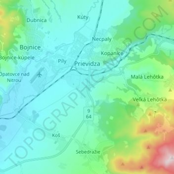
Nombre: Mapa topográfico Prievidza, altitud, relieve.
Altitud media: 346 m
Altitud mínima: 247 m
Altitud máxima: 815 m
Prievidza lies at an altitude of 280 metres (919 ft) above sea level and covers an area of 43.06 square kilometres (16.6 sq mi). The city is situated very near the smaller but more famous town of Bojnice, actually sharing the public transport system. The valley of the Nitra River, in which the city lies, is surrounded by mountain ranges on all sides, in the west Strážov Mountains, in the north Malá Fatra, in the east Žiar and in the south Vtáčnik. Prievidza is the eleventh largest city in Slovakia. It is located around 60 kilometres (37 mi) south of Žilina, 69 kilometres (43 mi) east of the regional capital Trenčín and 158 kilometres (98 mi) from capital city of Slovakia Bratislava (by road).
Otros mapas topográficos
Haga clic en un mapa para ver su topografía, su altitud y su relieve.
Nováky
Slovakia > Region of Trenčín > District of Prievidza
Nováky, District of Prievidza, Region of Trenčín, Western Slovakia, 972 71, Slovakia
Altitud media: 284 m
Nováky
Slovakia > Region of Trenčín > District of Prievidza > Nováky > Nováky
Nováky, District of Prievidza, Region of Trenčín, Western Slovakia, 972 71, Slovakia
Altitud media: 298 m