
Mapa topográfico El Gilf El Kebir Plateau
Mapa interactivo
Haga clic en el mapa para ver la altitud.
Acerca de este mapa
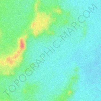
Nombre: Mapa topográfico El Gilf El Kebir Plateau, altitud, relieve.
Lugar: El Gilf El Kebir Plateau, New Valley Governorate, Egypt (23.38046 26.08927 23.40046 26.10927)
Altitud media: 1.037 m
Altitud mínima: 1.017 m
Altitud máxima: 1.088 m
Otros mapas topográficos
Haga clic en un mapa para ver su topografía, su altitud y su relieve.
Rashida
Egypt > New Valley Governorate > Rashida
Rashida, New Valley Governorate, Egypt
Altitud media: 101 m
El Dakhla Oasis
Egypt > New Valley Governorate > El Dakhla Oasis
El Dakhla Oasis, New Valley Governorate, Egypt
Altitud media: 205 m
Al-Farafra
Egypt > New Valley Governorate > Al-Farafra
Al-Farafra, New Valley Governorate, Egypt
Altitud media: 73 m
Al Izziyah
Egypt > New Valley Governorate > Al Izziyah
Al Izziyah, New Valley Governorate, Egypt
Altitud media: 68 m
Aulad Salama
Egypt > New Valley Governorate > Aulad Salama
Aulad Salama, New Valley Governorate, Egypt
Altitud media: 72 m
Dayr al Abyad
Egypt > New Valley Governorate
Dayr al Abyad, New Valley Governorate, Egypt
Altitud media: 137 m
Hawd Dandarah
Egypt > New Valley Governorate > Al Ashraf al Bahriyah
Hawd Dandarah, Al Ashraf al Bahriyah, New Valley Governorate, Egypt
Altitud media: 74 m