
Mapa topográfico Stratford-upon-Avon
Mapa interactivo
Haga clic en el mapa para ver la altitud.
Acerca de este mapa
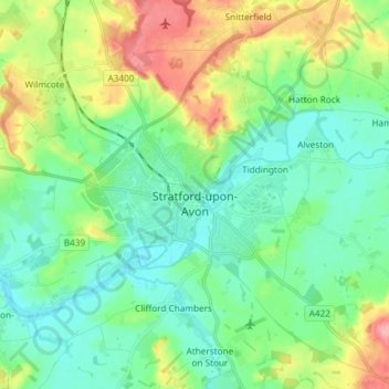
Nombre: Mapa topográfico Stratford-upon-Avon, altitud, relieve.
Altitud media: 61 m
Altitud mínima: 32 m
Altitud máxima: 129 m
Otros mapas topográficos
Haga clic en un mapa para ver su topografía, su altitud y su relieve.
Burton Dassett Hills Country Park
Vereinigtes Königreich > England > Warwickshire > Stratford-on-Avon > Northend > Burton Dassett CP
Burton Dassett Hills Country Park, Burton Dassett CP, Northend, Stratford-on-Avon, Warwickshire, England, Vereinigtes Königreich
Altitud media: 132 m