
Mapa topográfico Lake Columbia
Mapa interactivo
Haga clic en el mapa para ver la altitud.
Acerca de este mapa
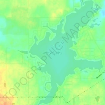
Nombre: Mapa topográfico Lake Columbia, altitud, relieve.
Altitud media: 307 m
Altitud mínima: 292 m
Altitud máxima: 326 m
Lake Columbia is a small man-made lake in Columbia Township in southern Jackson County in the U.S. state of Michigan. Originally formed as a mill pond in 1836, it was expanded to 840 acres (3.4 km2) in 1961. At its greatest extent, the lake is 2 and 1/4 miles long and 1 and 3/4 miles wide. It has approximately 14 miles (23 km) of shoreline and the water source to the lake is Goose Creek. The lake has an average depth of 18 feet (5.5 m). Lake Columbia is located 2 miles (3.2 km) west of Brooklyn, Michigan. The latitude for the lake is 42.0928 and the longitude is -84.3011 with an elevation of 988 ft (301 m) above sea level.