
Mapa topográfico Douglas County
Mapa interactivo
Haga clic en el mapa para ver la altitud.
Acerca de este mapa
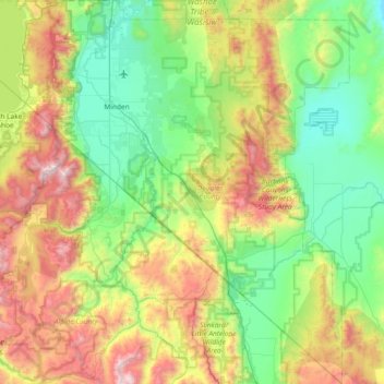
Nombre: Mapa topográfico Douglas County, altitud, relieve.
Lugar: Douglas County, Nevada, United States of America (38.53617 -120.00343 39.11401 -119.31548)
Altitud media: 1.940 m
Altitud mínima: 1.345 m
Altitud máxima: 3.308 m
According to the U.S. Census Bureau, the county has an area of 738 square miles (1,910 km2), of which 710 square miles (1,800 km2) is land and 28 square miles (73 km2) (3.8%) is water. It is the second-smallest county in Nevada by area. The highest point is East Peak at 9,593 ft (2,924 m), while the most topographically prominent mountain is Mount Siegel.
Otros mapas topográficos
Haga clic en un mapa para ver su topografía, su altitud y su relieve.
Death Valley
United States of America > Nevada
Death Valley, Beatty Wash Road, Nye County, Nevada, 92328, United States of America
Altitud media: 1.085 m