
Mapa topográfico Wolfenbüttel
Mapa interactivo
Haga clic en el mapa para ver la altitud.
Wolfenbüttel
The town center is located at an elevation of 77 ft (23 m) on the Oker river near the confluence with its Altenau tributary, about 13 km (8.1 mi) south of Brunswick and 60 km (37 mi) southeast of the state capital Hannover. Wolfenbüttel is situated about half-way between the Harz mountain range in the south and the Lüneburg Heath in the north. The Elm-Lappwald Nature Park and the Asse hill range stretch east and southeast of the town.
Acerca de este mapa
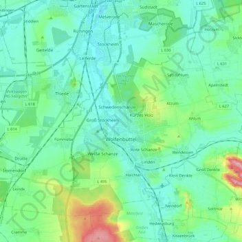
Nombre: Mapa topográfico Wolfenbüttel, altitud, relieve.
Lugar: Wolfenbüttel, Landkreis Wolfenbüttel, Lower Saxony, Germany (52.12086 10.43187 52.22351 10.64393)
Altitud media: 99 m
Altitud mínima: 68 m
Altitud máxima: 220 m