

Mapa topográfico Mount Robson
Haga clic en el mapa para ver la altitud.
Mount Robson
The north face can be seen from Berg Lake, and reached by a 19 km (12 mi) hike. The lake is approximately 2 km long and lies at 1,646 m (5,400 ft) elevation. There are backcountry campgrounds at each end of the lake and a log shelter on its banks, named Hargreaves Shelter in honor of the Hargreaves family who operated the Mount Robson Ranch across the Fraser River from the mountain and who outfitted most of the early trips into Berg Lake. The Berg Glacier calves directly into the lake. The Robson Glacier, which fills the cirque and valley between Mount Robson and Mount Resplendent, in the early 1900s fed directly into both Berg lake and Adolphus Lake, straddling the Continental Divide and draining thus to both the Arctic and Pacific oceans via the Smoky and Robson Rivers, respectively. It since has receded more than 2 kilometres and is the source of the Robson River only. The peak of Mount Robson has a tundra climate (ET).
Acerca de este mapa
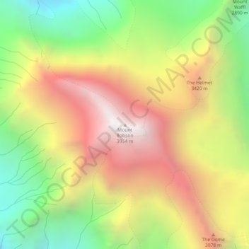
Nombre: Mapa topográfico Mount Robson, altitud, relieve.
Altitud media: 3.042 m
Altitud mínima: 2.174 m
Altitud máxima: 3.927 m
Otros mapas topográficos
Haga clic en un mapa para ver su topografía, su altitud y su relieve.
Berg Lake
Canada > British Columbia > Regional District of Fraser-Fort George > Area H (Robson Valley/Canoe)
Altitud media: 1.798 m