
Mapa topográfico Monkton Combe
Mapa interactivo
Haga clic en el mapa para ver la altitud.
Acerca de este mapa
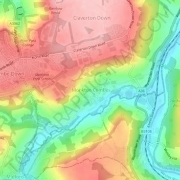
Nombre: Mapa topográfico Monkton Combe, altitud, relieve.
Altitud media: 102 m
Altitud mínima: 19 m
Altitud máxima: 178 m
Otros mapas topográficos
Haga clic en un mapa para ver su topografía, su altitud y su relieve.
Old Mills
United Kingdom > England > Bath and North East Somerset > Paulton
Old Mills, Paulton, Bath and North East Somerset, West of England, England, BS39 7SR, United Kingdom
Altitud media: 126 m
River Kennet
United Kingdom > England > Bath and North East Somerset
River Kennet, Bath and North East Somerset, West of England, England, RG1 6BT, United Kingdom, Kennet and Avon Canal
Altitud media: 47 m
Clandown
United Kingdom > England > Bath and North East Somerset > Radstock
Clandown, Radstock, Bath and North East Somerset, West of England, England, BA3 3DW, United Kingdom
Altitud media: 118 m
Peasedown St. John
United Kingdom > England > Bath and North East Somerset
Peasedown St. John, Bath and North East Somerset, West of England, England, United Kingdom
Altitud media: 125 m
Batheaston
United Kingdom > England > Bath and North East Somerset > Batheaston
Batheaston, Bath and North East Somerset, West of England, England, United Kingdom
Altitud media: 114 m
Bath
United Kingdom > England > Bath and North East Somerset
Bath, Bath and North East Somerset, West of England, England, United Kingdom
Altitud media: 100 m
Chew Magna
United Kingdom > England > Bath and North East Somerset > Chew Magna
Chew Magna, Bath and North East Somerset, West of England, England, United Kingdom
Altitud media: 90 m