
Mapa topográfico Ponkunnam
Mapa interactivo
Haga clic en el mapa para ver la altitud.
Acerca de este mapa
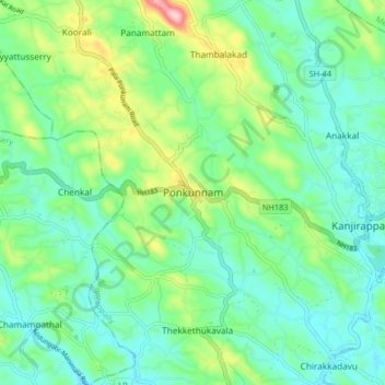
Nombre: Mapa topográfico Ponkunnam, altitud, relieve.
Altitud media: 83 m
Altitud mínima: 27 m
Altitud máxima: 238 m
Ponkunnam is a census town in Kerala, India, part of Kottayam district under Kanjirappally taluk. Ponkunnam literally means golden mountain (ponn = gold, kunn = mountain). Nearby towns are Kanjirappalli, Manimala and Pala. This part of Kerala is famous for its fertile land and rubber plantations. It is at an altitude of 495 ft (151 m) above mean sea level. The town is at the junction of two major roads in Kerala: NH 183 and Main Eastern Highway. The climate is moderate with timely cold breezes and the town is the gateway to the Western Ghats. The town is famous for its volleyball traditions and customs. Almost every year there is an ever-rolling volleyball tournament happening in Ponkunnam Mahatma Gandhi Mini Stadium.
Otros mapas topográficos
Haga clic en un mapa para ver su topografía, su altitud y su relieve.
Elivalikkara
India > Kerala > Kanjirappally > Mukkoottuthara
Elivalikkara, Mukkoottuthara, Kanjirappally, Kottayam District, Kerala, India
Altitud media: 167 m
Kunnumbhagam
India > Kerala > Kanjirappally > Kanjirappalli
Kunnumbhagam, Kanjirappalli, Kanjirappally, Kottayam District, Kerala, 686507, India
Altitud media: 74 m
Podimattom
India > Kerala > Kanjirappally
Podimattom, Kanjirappally, Kottayam District, Kerala, 686512, India
Altitud media: 83 m
Mukkada
India > Kerala > Kanjirappally
Mukkada, Kanjirappally, Kottayam, Kerala, 686511, India
Altitud media: 108 m
Nadukani
India > Kerala > Kanjirappally > Mundakkayam
Nadukani, Mundakkayam, Kanjirappally, Kottayam, Kerala, 686513, India
Altitud media: 159 m
Parathodu (28Mile)
India > Kerala > Kanjirappally
Parathodu (28Mile), Kanjirappally, Kottayam, Kerala, 686512, India
Altitud media: 104 m
Chenappady
India > Kerala > Kanjirappally > Chenappady
Chenappady, Kanjirappally, Kottayam, Kerala, 686520, India
Altitud media: 64 m
Koratty
India > Kerala > Kanjirappally
Koratty, Kanjirappally, Kottayam, Kerala, 686509, India
Altitud media: 75 m