
Mapa topográfico Middleton ED
Mapa interactivo
Haga clic en el mapa para ver la altitud.
Acerca de este mapa
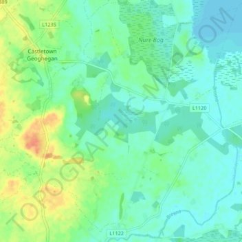
Nombre: Mapa topográfico Middleton ED, altitud, relieve.
Altitud media: 89 m
Altitud mínima: 77 m
Altitud máxima: 116 m
Otros mapas topográficos
Haga clic en un mapa para ver su topografía, su altitud y su relieve.
Copperalley ED
Copperalley ED, The Municipal District of Mullingar — Kinnegad, County Westmeath, Condado de Westmeath, Leinster, Irlanda
Altitud media: 78 m
Mullingar
Irlanda > County Westmeath > Mullingar
Mullingar, The Municipal District of Mullingar — Kinnegad, County Westmeath, Leinster, N91 FY58, Irlanda
Altitud media: 101 m