
Mapa topográfico Glenford
Mapa interactivo
Haga clic en el mapa para ver la altitud.
Acerca de este mapa
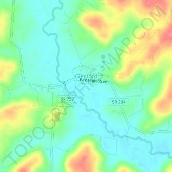
Nombre: Mapa topográfico Glenford, altitud, relieve.
Lugar: Glenford, Perry County, Ohio, United States (39.88329 -82.32481 39.88976 -82.31251)
Altitud media: 273 m
Altitud mínima: 248 m
Altitud máxima: 320 m
Otros mapas topográficos
Haga clic en un mapa para ver su topografía, su altitud y su relieve.
Portersville
United States > Ohio > Perry County
Portersville, Perry County, Ohio, United States
Altitud media: 302 m
Corning
United States > Ohio > Perry County
Corning, Perry County, Ohio, United States
Altitud media: 254 m
Shawnee
United States > Ohio > Perry County
Shawnee, Perry County, Ohio, 43782, United States
Altitud media: 278 m
New Straitsville
United States > Ohio > Perry County
New Straitsville, Perry County, Ohio, United States
Altitud media: 278 m
Mount Perry
United States > Ohio > Perry County
Mount Perry, Perry County, Ohio, 43760, United States
Altitud media: 273 m
Crooksville
United States > Ohio > Perry County
Crooksville, Perry County, Ohio, United States
Altitud media: 261 m
Glass Rock
United States > Ohio > Perry County
Glass Rock, Perry County, Ohio, 43739, United States
Altitud media: 283 m
New Lexington
United States > Ohio > Perry County
New Lexington, Perry County, Ohio, United States
Altitud media: 279 m