
Mapa topográfico Newkirk
Mapa interactivo
Haga clic en el mapa para ver la altitud.
Acerca de este mapa
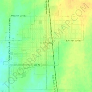
Nombre: Mapa topográfico Newkirk, altitud, relieve.
Lugar: Newkirk, Kay County, Oklahoma, 74647, United States (36.86857 -97.06925 36.89420 -97.04001)
Altitud media: 350 m
Altitud mínima: 335 m
Altitud máxima: 361 m
Newkirk's elevation is 1,152 feet (351 m). It is on mostly flat terrain with no large watercourses nearby, and at the boundary between two ecoregions: the Central Great Plains and the Flint Hills. West of the town on the Great Plains, the countryside is rich agricultural land, especially for wheat, soybeans, and cattle. East of town, the Flint Hills' terrain is more rugged and rocky and is primarily used for cattle ranching. Natural vegetation is mostly prairie, but stream valleys often have forests of cottonwood, oak, elm, ash, pecan, sycamore, and other species. Scrub oak and red cedar dot hillsides. Wildlife is abundant, including whitetail deer, turkey, bobwhite quail, coyote, bobcat, and waterfowl. A cougar attack on a person seven miles (11 km) east of Newkirk was reported in 2002.
Otros mapas topográficos
Haga clic en un mapa para ver su topografía, su altitud y su relieve.
Tonkawa
United States > Oklahoma > Kay County
Tonkawa, Kay County, Oklahoma, 74653, United States
Altitud media: 300 m
Ponca City
United States > Oklahoma > Kay County
Ponca City, Kay County, Oklahoma, United States
Altitud media: 308 m
Ponca City
United States > Oklahoma > Kay County > Ponca City > Ponca City
Ponca City, Kay County, Oklahoma, 74601, United States
Altitud media: 302 m
Blackwell
United States > Oklahoma > Kay County
Blackwell, Kay County, Oklahoma, 74631, United States
Altitud media: 312 m