
Haz una donación
Equípate para tu próxima aventura:
Como asociado de Amazon, este sitio gana comisiones por las compras que califican, sin ningún costo adicional para usted.
Mapa topográfico Oenaville
Haga clic en el mapa para ver la altitud.
Haz una donación
Equípate para tu próxima aventura:
Como asociado de Amazon, este sitio gana comisiones por las compras que califican, sin ningún costo adicional para usted.
Acerca de este mapa
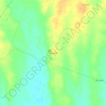
Nombre: Mapa topográfico Oenaville, altitud, relieve.
Lugar: Oenaville, Bell County, Texas, United States (31.10768 -97.24833 31.14768 -97.20833)
Altitud media: 168 m
Altitud mínima: 154 m
Altitud máxima: 183 m
Haz una donación
Equípate para tu próxima aventura:
Como asociado de Amazon, este sitio gana comisiones por las compras que califican, sin ningún costo adicional para usted.
Otros mapas topográficos
Haga clic en un mapa para ver su topografía, su altitud y su relieve.
Belton
United States > Texas > Bell County
Belton is located 60 miles (97 km) north of Austin,[11] 137 miles (220 km) south of Dallas,[12] and 184 miles (296 km) west of Houston.[13] It is near the center of Bell County at 31°3′32″N 97°27′48″W / 31.05889°N 97.46333°W / 31.05889; -97.46333 (31.058904, –97.463382).[14] It is at the…
Altitud media: 179 m
Haz una donación
Equípate para tu próxima aventura:
Como asociado de Amazon, este sitio gana comisiones por las compras que califican, sin ningún costo adicional para usted.
Haz una donación
Equípate para tu próxima aventura:
Como asociado de Amazon, este sitio gana comisiones por las compras que califican, sin ningún costo adicional para usted.
Belton
United States > Texas > Bell County
Belton is located 60 miles (97 km) north of Austin, 137 miles (220 km) south of Dallas, and 184 miles (296 km) west of Houston. It is near the center of Bell County at the point where the Blackland Prairie, characterized by level ground and deep fertile soil, and the Edwards Plateau, characterized by its many…
Altitud media: 179 m
Haz una donación
Equípate para tu próxima aventura:
Como asociado de Amazon, este sitio gana comisiones por las compras que califican, sin ningún costo adicional para usted.
Belton
United States > Texas > Bell County
Belton is located 60 miles (97 km) north of Austin, 137 miles (220 km) south of Dallas, and 184 miles (296 km) west of Houston. It is near the center of Bell County at the point where the Blackland Prairie, characterized by level ground and deep fertile soil, and the Edwards Plateau, characterized by its many…
Altitud media: 181 m
Belton
United States > Texas > Bell County
Belton is located 60 miles (97 km) north of Austin, 137 miles (220 km) south of Dallas, and 184 miles (296 km) west of Houston. It is near the center of Bell County at 31°3′32″N 97°27′48″W / 31.05889°N 97.46333°W / 31.05889; -97.46333 (31.058904, –97.463382). Belton is at the point where…
Altitud media: 179 m
Haz una donación
Equípate para tu próxima aventura:
Como asociado de Amazon, este sitio gana comisiones por las compras que califican, sin ningún costo adicional para usted.