
Mapa topográfico Lawton
Mapa interactivo
Haga clic en el mapa para ver la altitud.
Acerca de este mapa
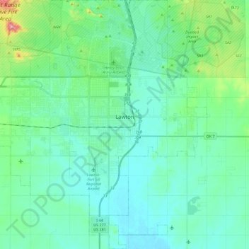
Nombre: Mapa topográfico Lawton, altitud, relieve.
Lugar: Lawton, Comanche County, Oklahoma, United States (34.51150 -98.53649 34.69435 -98.31443)
Altitud media: 352 m
Altitud mínima: 314 m
Altitud máxima: 525 m
Developed on former reservation lands of the Kiowa, Comanche, and Apache Indians, Lawton was founded by European Americans on 6 August 1901. It was named after Major General Henry Ware Lawton, who served in the Civil War, where he earned the Medal of Honor, and was killed in action in the Philippine–American War. Lawton's landscape is typical of the Great Plains, with flat topography and gently rolling hills, while the area north of the city is marked by the Wichita Mountains.
Otros mapas topográficos
Haga clic en un mapa para ver su topografía, su altitud y su relieve.
Jackson Hole
United States > Oklahoma > Comanche County
Jackson Hole, Comanche County, Oklahoma, United States
Altitud media: 406 m
Meers
United States > Oklahoma > Comanche County
Meers, Comanche County, Oklahoma, United States
Altitud media: 457 m
Lake Lawtonka
United States > Oklahoma > Comanche County
Lake Lawtonka, Comanche County, Oklahoma, United States
Altitud media: 428 m
Indiahoma
United States > Oklahoma > Comanche County
Indiahoma, Comanche County, Oklahoma, United States
Altitud media: 405 m
Geronimo
United States > Oklahoma > Comanche County
Geronimo, Comanche County, Oklahoma, 73543, United States
Altitud media: 328 m
Chattanooga
United States > Oklahoma > Comanche County
Chattanooga, Comanche County, Oklahoma, 73528, United States
Altitud media: 347 m
Faxon
United States > Oklahoma > Comanche County
Faxon, Comanche County, Oklahoma, United States
Altitud media: 334 m
Sterling
United States > Oklahoma > Comanche County
Sterling, Comanche County, Oklahoma, 73567, United States
Altitud media: 372 m
Fletcher
United States > Oklahoma > Comanche County
Fletcher, Comanche County, Oklahoma, United States
Altitud media: 417 m
Cache
United States > Oklahoma > Comanche County
Cache, Comanche County, Oklahoma, 73527, United States
Altitud media: 386 m
Fort Sill
United States > Oklahoma > Comanche County
Fort Sill, Comanche County, Oklahoma, United States
Altitud media: 417 m
Elk Mountain
United States > Oklahoma > Comanche County
Elk Mountain, Comanche County, Oklahoma, United States
Altitud media: 543 m
Elgin
United States > Oklahoma > Comanche County
Elgin, Comanche County, Oklahoma, United States
Altitud media: 393 m
Pratt Hill
United States > Oklahoma > Comanche County
Pratt Hill, Comanche County, Oklahoma, 73557, United States
Altitud media: 442 m
Lawton
United States > Oklahoma > Comanche County > Lawton
Lawton, Comanche County, Oklahoma, 73501, United States
Altitud media: 361 m
Mount McKinley
United States > Oklahoma > Comanche County
Mount McKinley, Comanche County, Oklahoma, United States
Altitud media: 498 m
Cove Acres
United States > Oklahoma > Comanche County > Cove Acres
Cove Acres, Comanche County, Oklahoma, 73006, United States
Altitud media: 381 m
Cross Mountain
United States > Oklahoma > Comanche County
Cross Mountain, Comanche County, Oklahoma, United States
Altitud media: 530 m
Medicine Park
United States > Oklahoma > Comanche County
Medicine Park, Comanche County, Oklahoma, 73557, United States
Altitud media: 429 m