
Haz una donación
Equípate para tu próxima aventura:
Como asociado de Amazon, este sitio gana comisiones por las compras que califican, sin ningún costo adicional para usted.
Mapa topográfico Springfield
Haga clic en el mapa para ver la altitud.
Haz una donación
Equípate para tu próxima aventura:
Como asociado de Amazon, este sitio gana comisiones por las compras que califican, sin ningún costo adicional para usted.
Springfield
Springfield is situated on a gently rolling plateau at an average elevation of approximately 1,310 feet (400 meters) above sea level. The region is characterized by a mix of flatlands and gradual slopes that rise toward the nearby Ozark Mountains, which can be found to the south and east. The local terrain features several creeks and small rivers, such as the James River, which meanders through the area, contributing to the diverse landscape. Additionally, the presence of Lake Springfield—a reservoir with an elevation of about 1,142 feet (348 meters)—adds to the scenic variety, providing recreational opportunities and serving as a vital water resource.
Haz una donación
Equípate para tu próxima aventura:
Como asociado de Amazon, este sitio gana comisiones por las compras que califican, sin ningún costo adicional para usted.
Acerca de este mapa
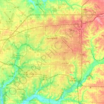
Nombre: Mapa topográfico Springfield, altitud, relieve.
Lugar: Springfield, Greene County, Missouri, United States (37.08879 -93.41322 37.27698 -93.17850)
Altitud media: 389 m
Altitud mínima: 332 m
Altitud máxima: 446 m
Haz una donación
Equípate para tu próxima aventura:
Como asociado de Amazon, este sitio gana comisiones por las compras que califican, sin ningún costo adicional para usted.
Otros mapas topográficos
Haga clic en un mapa para ver su topografía, su altitud y su relieve.
Haz una donación
Equípate para tu próxima aventura:
Como asociado de Amazon, este sitio gana comisiones por las compras que califican, sin ningún costo adicional para usted.