Geolocalizar
👉 Easily get elevation data in JSON, GeoTIFF and KML formats using Elevation API
Gracias por apoyar a este sitio ❤️
Haz una donación

Equípate para tu próxima aventura:

Como asociado de Amazon, este sitio gana comisiones por las compras que califican, sin ningún costo adicional para usted.

Mapa topográfico Stratford

Haga clic en el mapa para ver la altitud.

Stratford

According to Lewis's Topographical Dictionary of 1837, Stratford-upon-Slaney was at that time a market town in the barony of Upper Talbotstown 2¼ miles north north east of Baltinglass. At that time the town had 2,833 inhabitants. In 1837 Orr and Co. bought the factory from the Stratford family. It employed about 1,000 people and turned out about 2,000 finished pieces per week. The factory had a canal that brought water directly to the wheel and it was seen as the best wheel in Ireland, the factory was fitted quite ideally for manufacturing of cotton.

Acerca de este mapa

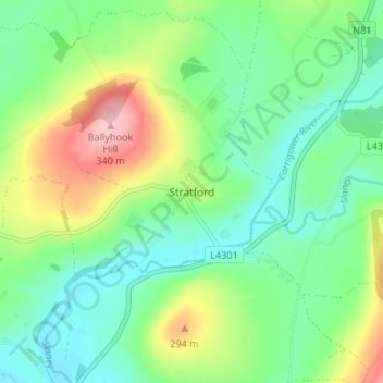
Nombre: Mapa topográfico Stratford, altitud, relieve.

Lugar: Stratford, The Municipal District of Baltinglass, County Wicklow, Leinster, W91 R2D3, Ireland (52.96788 -6.69345 53.00788 -6.65345)

Altitud media: 174 m

Altitud mínima: 119 m

Altitud máxima: 288 m

Equípate para tu próxima aventura:

🥾Polainas de senderismo - Protección contra barro y nieve
💦Filtros de Agua Portátiles - Bebe directamente de arroyos con total seguridad
🪜Cordinos de seguridad - Apoyo técnico en montaña
🧯Botiquines de primeros auxilios - Seguridad básica en montaña
🗺️Fundas Portamapas Estancas - Lee tus mapas bajo la lluvia sin dañarlos

Como asociado de Amazon, este sitio gana comisiones por las compras que califican, sin ningún costo adicional para usted.