
Mapa topográfico Portrush
Mapa interactivo
Haga clic en el mapa para ver la altitud.
Acerca de este mapa
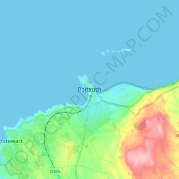
Nombre: Mapa topográfico Portrush, altitud, relieve.
Altitud media: 23 m
Altitud mínima: -1 m
Altitud máxima: 131 m
Otros mapas topográficos
Haga clic en un mapa para ver su topografía, su altitud y su relieve.
Carrickfergus
United Kingdom > Northern Ireland > County Antrim
Carrickfergus, County Antrim, Ulster, Northern Ireland, BT38 7AF, United Kingdom
Altitud media: 49 m
Ahoghill
United Kingdom > Northern Ireland > County Antrim
Ahoghill, County Antrim, Ulster, Northern Ireland, BT42 1JZ, United Kingdom
Altitud media: 84 m
Ballymena
United Kingdom > Northern Ireland > County Antrim
Ballymena, County Antrim, Northern Ireland, BT43 6DT, United Kingdom
Altitud media: 74 m
Larne
United Kingdom > Northern Ireland > County Antrim
Larne, County Antrim, Northern Ireland, BT40 1JS, United Kingdom
Altitud media: 54 m
Belfast
United Kingdom > Northern Ireland > County Antrim
Belfast, County Antrim, Ulster, Northern Ireland, BT1 5GS, United Kingdom
Altitud media: 87 m
Antrim
United Kingdom > Northern Ireland > County Antrim
Antrim, County Antrim, Northern Ireland, BT41 4AR, United Kingdom
Altitud media: 50 m