
Haz una donación
Equípate para tu próxima aventura:
Como asociado de Amazon, este sitio gana comisiones por las compras que califican, sin ningún costo adicional para usted.
Mapa topográfico Chisos Mountains
Haga clic en el mapa para ver la altitud.
Haz una donación
Equípate para tu próxima aventura:
Como asociado de Amazon, este sitio gana comisiones por las compras que califican, sin ningún costo adicional para usted.
Acerca de este mapa
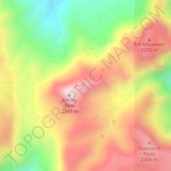
Nombre: Mapa topográfico Chisos Mountains, altitud, relieve.
Lugar: Chisos Mountains, Brewster County, Texas, United States (29.24726 -103.30227 29.24736 -103.30217)
Altitud media: 2.053 m
Altitud mínima: 1.683 m
Altitud máxima: 2.367 m
Haz una donación
Equípate para tu próxima aventura:
Como asociado de Amazon, este sitio gana comisiones por las compras que califican, sin ningún costo adicional para usted.
Otros mapas topográficos
Haga clic en un mapa para ver su topografía, su altitud y su relieve.
Alpine
United States > Texas > Brewster County
Alpine (/ˈælpaɪn/ AL-pyne) is a city in the county seat of Brewster County, Texas, United States. The population was 5,905 at the 2010 census. The town has an elevation of 4,475 feet (1,364 m), and the surrounding mountain peaks are over 1 mile (1.6 km) above sea level. The university, hospital, library,…
Altitud media: 1.373 m
Big Bend National Park
United States > Texas > Brewster County
Big Bend National Park is an American national park located in West Texas, bordering Mexico. The park has national significance as the largest protected area of Chihuahuan Desert topography and ecology in the United States, and was named after a large bend in the Rio Grande/Río Bravo. The park protects more…
Altitud media: 934 m
Alpine
United States > Texas > Brewster County
Alpine (/ˈælpaɪn/ AL-pyne) is a city in and the county seat of Brewster County, Texas, United States. The population was 6,035 at the 2020 census. The town has an elevation of 4,462 feet (1,360 m), and the surrounding mountain peaks are over 1 mile (1.6 km) above sea level. A university, hospital, library,…
Altitud media: 1.373 m
Haz una donación
Equípate para tu próxima aventura:
Como asociado de Amazon, este sitio gana comisiones por las compras que califican, sin ningún costo adicional para usted.
Big Bend National Park
United States > Texas > Brewster County
Big Bend National Park is an American national park located in West Texas, bordering Mexico. The park has national significance as the largest protected area of Chihuahuan Desert topography and ecology in the United States, and was named after a large bend in the Rio Grande/Río Bravo. The park protects more…
Altitud media: 934 m
Alpine
United States > Texas > Brewster County
Alpine (/ˈælpaɪn/ AL-pyne) is a city in the county seat of Brewster County, Texas, United States. The population was 5,905 at the 2010 census. The town has an elevation of 4,475 feet (1,364 m), and the surrounding mountain peaks are over 1 mile (1.6 km) above sea level. The university, hospital, library,…
Altitud media: 1.373 m