Geolocalizar

Mapa topográfico Lake Sebu

Haga clic en el mapa para ver la altitud.

Lake Sebu

The placid lake of Lake Sebu can be found in Allah Valley near the municipality of Surallah, South Cotabato. Surrounded by rolling hills and mountains covered with thick rain forest, the lake has an area of 361.124 hectares (892.36 acres), with an elevation of approximately 1,000 metres (3,300 ft).

Wikipedia (CC-BY-SA 3.0)

Acerca de este mapa

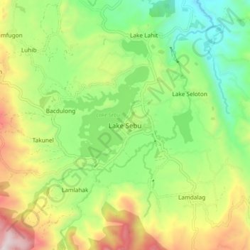
Nombre: Mapa topográfico Lake Sebu, altitud, relieve.

Lugar: Lake Sebu, South Cotabato, Soccsksargen, 9514, Philippines (6.18600 124.67157 6.26600 124.75157)

Altitud media: 750 m

Altitud mínima: 344 m

Altitud máxima: 1.389 m

Otros mapas topográficos

Haga clic en un mapa para ver su topografía, su altitud y su relieve.

Polomolok

Philippines > South Cotabato

Altitud media: 485 m

Lake Sebu

Philippines > South Cotabato

The placid lake of Lake Sebu can be found in Allah Valley near the municipality of Surallah, South Cotabato. Surrounded by rolling hills and mountains covered with thick rain forest, the lake has an area of 361.124 hectares (892.36 acres), with an elevation of approximately 1,000 metres (3,300 ft).

Altitud media: 710 m

Koronadal

Philippines > South Cotabato

The city's landscape features a combination of flatlands and gently sloping terrain, with approximately 50.18% of its total land area classified as predominantly flat. It is flanked by the Roxas and Quezon mountain ranges, whose elevations reach between 700 to 800 meters above sea level and gradually slope…

Altitud media: 164 m

Tupi

Philippines > South Cotabato

Altitud media: 460 m

Tampakan

Philippines > South Cotabato

Altitud media: 285 m

Saravia

Philippines > South Cotabato > Koronadal

Altitud media: 273 m

Rotonda

Philippines > South Cotabato > Koronadal

Altitud media: 57 m

Zone III

Philippines > South Cotabato > Koronadal

Altitud media: 82 m

Lake Sebu

Philippines > South Cotabato

The placid lake of Lake Sebu can be found in Allah Valley near the municipality of Surallah, South Cotabato. Surrounded by rolling hills and mountains covered with thick rain forest, the lake has an area of 361.124 hectares (892.36 acres), with an elevation of approximately 1,000 metres (3,300 ft).

Altitud media: 710 m

Polomolok

Philippines > South Cotabato

Altitud media: 498 m

T'Boli

Philippines > South Cotabato

Altitud media: 755 m

San Jose

Philippines > South Cotabato > Koronadal

Altitud media: 102 m

Paraiso

Philippines > South Cotabato > Koronadal

Altitud media: 104 m

Topland

Philippines > South Cotabato > Koronadal

Altitud media: 147 m

Tupi

Philippines > South Cotabato

Altitud media: 457 m

Polomolok

Philippines > South Cotabato

Altitud media: 485 m

T'Boli

Philippines > South Cotabato

Altitud media: 792 m

Koronadal

Philippines > South Cotabato

Altitud media: 164 m

Polomolok

Philippines > South Cotabato

Altitud media: 485 m

Surallah

Philippines > South Cotabato

Altitud media: 419 m

Caloocan

Philippines > South Cotabato > Koronadal

Altitud media: 42 m

Lake Holon

Philippines > South Cotabato > T'Boli

Altitud media: 1.452 m

Equípate para tu próxima aventura:

🔋Power Banks de Gran Capacidad - Carga varias veces tu móvil y GPS
📡Radios de emergencia - Comunicación sin cobertura
🧭Navegación terrestre - Herramientas para orientación
🔥Iniciadores de Fuego - Asegura tu calor y cocina incluso en condiciones húmedas
🧱Fundas impermeables móvil - Protección del smartphone

Como asociado de Amazon, este sitio gana comisiones por las compras que califican, sin ningún costo adicional para usted.