
Haz una donación
Equípate para tu próxima aventura:
Como asociado de Amazon, este sitio gana comisiones por las compras que califican, sin ningún costo adicional para usted.
Mapa topográfico Titisee
Haga clic en el mapa para ver la altitud.
Haz una donación
Equípate para tu próxima aventura:
Como asociado de Amazon, este sitio gana comisiones por las compras que califican, sin ningún costo adicional para usted.
Titisee
Der Ortsteil Titisee von Titisee-Neustadt liegt am Nordufer des Titisees, im Osten des Feldbergs im Schwarzwald in 780 bis 1190 Meter Höhe. Der Ortsteil Neustadt befindet sich fünf Kilometer östlich davon. Die Stadt liegt an einem kleinen Fluss, der als Seebach vom Bärental kommend den Titisee speist, als Gutach (gute Ach) aus diesem fließt und östlich des Stadtteils Neustadt als reißender Fluss Wutach (wütende Ach) das Stadtgebiet wieder verlässt und sich durch die bekannte Wutachschlucht schließlich in den Rhein ergießt.
Haz una donación
Equípate para tu próxima aventura:
Como asociado de Amazon, este sitio gana comisiones por las compras que califican, sin ningún costo adicional para usted.
Acerca de este mapa
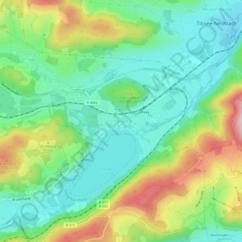
Nombre: Mapa topográfico Titisee, altitud, relieve.
Altitud media: 917 m
Altitud mínima: 824 m
Altitud máxima: 1.098 m
Haz una donación
Equípate para tu próxima aventura:
Como asociado de Amazon, este sitio gana comisiones por las compras que califican, sin ningún costo adicional para usted.