
Mapa topográfico Lingen (Ems)
Mapa interactivo
Haga clic en el mapa para ver la altitud.
Acerca de este mapa
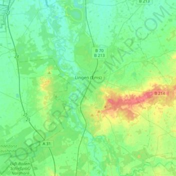
Nombre: Mapa topográfico Lingen (Ems), altitud, relieve.
Lugar: Lingen (Ems), Landkreis Emsland, Lower Saxony, Germany (52.42012 7.19355 52.60221 7.45399)
Altitud media: 29 m
Altitud mínima: 14 m
Altitud máxima: 72 m
Otros mapas topográficos
Haga clic en un mapa para ver su topografía, su altitud y su relieve.
Emsbüren
Germany > Lower Saxony > Landkreis Emsland
Emsbüren, Landkreis Emsland, Lower Saxony, 48488, Germany
Altitud media: 32 m
Wörmer
Germany > Lower Saxony > Landkreis Emsland > Haren (Ems) > Wesuwe
Wörmer, Wesuwe, Haren (Ems), Landkreis Emsland, Lower Saxony, 49733, Germany
Altitud media: 12 m
Dever
Germany > Lower Saxony > Landkreis Emsland > Lehe
Dever, Lehe, Samtgemeinde Dörpen, Landkreis Emsland, Lower Saxony, 26892, Germany
Altitud media: 6 m