
Mapa topográfico Dorbod Banner
Haga clic en el mapa para ver la altitud.
Dorbod Banner
The banner is located along the northern foothills of the Yin Mountains, and has an average elevation of 1,400 metres (4,600 ft).[3] Most of the banner's area is grassland.[3]
Acerca de este mapa
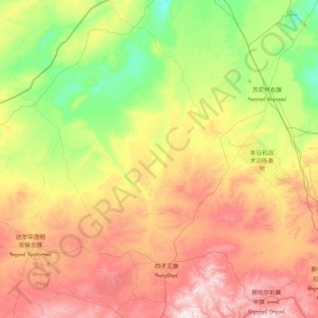
Nombre: Mapa topográfico Dorbod Banner, altitud, relieve.
Lugar: Dorbod Banner, Ulanqab City, Inner Mongolia, China (41.19250 110.33398 43.37933 112.99498)
Altitud media: 1.294 m
Altitud mínima: 926 m
Altitud máxima: 2.165 m
Otros mapas topográficos
Haga clic en un mapa para ver su topografía, su altitud y su relieve.