
Haz una donación
Equípate para tu próxima aventura:
Como asociado de Amazon, este sitio gana comisiones por las compras que califican, sin ningún costo adicional para usted.
Mapa topográfico Langeberg Local Municipality
Haga clic en el mapa para ver la altitud.
Haz una donación
Equípate para tu próxima aventura:
Como asociado de Amazon, este sitio gana comisiones por las compras que califican, sin ningún costo adicional para usted.
Acerca de este mapa
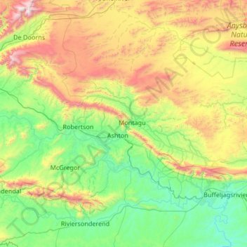
Nombre: Mapa topográfico Langeberg Local Municipality, altitud, relieve.
Altitud media: 589 m
Altitud mínima: 7 m
Altitud máxima: 2.212 m
Haz una donación
Equípate para tu próxima aventura:
Como asociado de Amazon, este sitio gana comisiones por las compras que califican, sin ningún costo adicional para usted.
Otros mapas topográficos
Haga clic en un mapa para ver su topografía, su altitud y su relieve.
Stellenbosch
South Africa > Western Cape > Cape Winelands District Municipality > Stellenbosch Local Municipality
Stellenbosch is 53 km (33 mi) east of Cape Town via National Route N1. Stellenbosch is in a hilly region of the Cape Winelands, and is sheltered in a valley at an average elevation of 136 m (446 ft), flanked on the west by Papegaaiberg (Afrikaans: Parrot Mountain), which is actually a hill. To the south is…
Altitud media: 287 m
Paarl Mountain Nature Reserve
South Africa > Western Cape > Cape Winelands District Municipality > Paarl
Altitud media: 395 m
Franschhoek
South Africa > Western Cape > Cape Winelands District Municipality > Stellenbosch Local Municipality
Altitud media: 502 m
Haz una donación
Equípate para tu próxima aventura:
Como asociado de Amazon, este sitio gana comisiones por las compras que califican, sin ningún costo adicional para usted.
Klapmuts
South Africa > Western Cape > Cape Winelands District Municipality > Stellenbosch Local Municipality
Altitud media: 186 m
Touws River
South Africa > Western Cape > Cape Winelands District Municipality > Breede Valley Local Municipality
Touws River is located at an elevation of 770 metres (2,530 ft) on the southwestern edge of the Great Karoo, east of the Hex River Mountains and north of the Langeberg, at the point where the Donkeys River flows into the Touws River. It lies just to the south of the N1 highway, 180 kilometres (110 mi) by road…
Altitud media: 822 m
Stellenbosch
South Africa > Western Cape > Cape Winelands District Municipality > Stellenbosch Local Municipality
Stellenbosch is 53 km (33 mi) east of Cape Town via National Route N1. Stellenbosch is in a hilly region of the Cape Winelands, and is sheltered in a valley at an average elevation of 136 m (446 ft), flanked on the west by Papegaaiberg (Afrikaans: Parrot Mountain), which is actually a hill. To the south is…
Altitud media: 222 m
Montagu
South Africa > Western Cape > Cape Winelands District Municipality > Langeberg Local Municipality
Altitud media: 434 m
Haz una donación
Equípate para tu próxima aventura:
Como asociado de Amazon, este sitio gana comisiones por las compras que califican, sin ningún costo adicional para usted.
Ceres
South Africa > Western Cape > Cape Winelands District Municipality > Witzenberg Local Municipality
Ceres experiences a typical Mediterranean climate tempered by its altitude. The town experiences warmer temperatures in summer, due to its inland location with infrequent rainfall, however winters are cool to quite cold and wet, with frequent snowfalls on the surrounding higher-lying ground, rarely falling on…
Altitud media: 586 m
Worcester
South Africa > Western Cape > Cape Winelands District Municipality > Breede Valley Local Municipality
Worcester is located at an elevation of 220 metres (720 ft) and can be reached by road either travelling on the N1 highway through the Huguenot Tunnel or by driving through spectacular mountain passes. From Cape Town Du Toitskloof, from Wellington Bainskloof, from Malmesbury, Western Cape Nieuwekloof, from…
Altitud media: 252 m
Hex River
South Africa > Western Cape > Cape Winelands District Municipality > Breede Valley Local Municipality
Altitud media: 644 m
Haz una donación
Equípate para tu próxima aventura:
Como asociado de Amazon, este sitio gana comisiones por las compras que califican, sin ningún costo adicional para usted.
Loskop
South Africa > Western Cape > Cape Winelands District Municipality > Breede Valley Local Municipality
Altitud media: 561 m
Robertson
South Africa > Western Cape > Cape Winelands District Municipality > Langeberg Local Municipality
Altitud media: 249 m
De Doorns
South Africa > Western Cape > Cape Winelands District Municipality > Breede Valley Local Municipality
Altitud media: 683 m
Driekop
South Africa > Western Cape > Cape Winelands District Municipality > Stellenbosch Local Municipality
Altitud media: 557 m
Haz una donación
Equípate para tu próxima aventura:
Como asociado de Amazon, este sitio gana comisiones por las compras que califican, sin ningún costo adicional para usted.
Groot-Drakenstein
South Africa > Western Cape > Cape Winelands District Municipality > Stellenbosch Local Municipality
Altitud media: 173 m
Nduli
South Africa > Western Cape > Cape Winelands District Municipality > Witzenberg Local Municipality
Altitud media: 503 m
Wolseley
South Africa > Western Cape > Cape Winelands District Municipality > Witzenberg Local Municipality
Wolseley lies at an altitude of 260 metres (850 ft) on the watershed between the drainage basins of the Breede River, which flows south to the Indian Ocean, and the Berg River, which flows north to the Atlantic Ocean. It is 15 kilometres (9 mi) south of Tulbagh, 12 kilometres (7 mi) southwest of Ceres, and 35…
Altitud media: 271 m
Ashton
South Africa > Western Cape > Cape Winelands District Municipality > Langeberg Local Municipality
Altitud media: 243 m
Haz una donación
Equípate para tu próxima aventura:
Como asociado de Amazon, este sitio gana comisiones por las compras que califican, sin ningún costo adicional para usted.
Wemmershoek Dam
South Africa > Western Cape > Cape Winelands District Municipality > Paarl
Altitud media: 396 m
Baviaanshoek
South Africa > Western Cape > Cape Winelands District Municipality > Witzenberg Local Municipality
Altitud media: 1.181 m
Eerste River
South Africa > Western Cape > Cape Winelands District Municipality > Stellenbosch Local Municipality > Stellenbosch
Altitud media: 104 m
Breede River
South Africa > Western Cape > Cape Winelands District Municipality > Breede Valley Local Municipality
Altitud media: 219 m
Haz una donación
Equípate para tu próxima aventura:
Como asociado de Amazon, este sitio gana comisiones por las compras que califican, sin ningún costo adicional para usted.
Matroosberg
South Africa > Western Cape > Cape Winelands District Municipality > Witzenberg Local Municipality
Altitud media: 1.887 m
Franschhoek
South Africa > Western Cape > Cape Winelands District Municipality > Stellenbosch Local Municipality
Altitud media: 502 m
Wellington
South Africa > Western Cape > Cape Winelands District Municipality > Drakenstein Local Municipality
Altitud media: 168 m
Stellenbosch
South Africa > Western Cape > Cape Winelands District Municipality > Stellenbosch Local Municipality
Stellenbosch is 53 km (33 mi) east of Cape Town via National Route N1. Stellenbosch is in a hilly region of the Cape Winelands, and is sheltered in a valley at an average elevation of 136 m (446 ft), flanked on the west by Papegaaiberg (Afrikaans: Parrot Mountain), which is actually a hill. To the south is…
Altitud media: 287 m
Haz una donación
Equípate para tu próxima aventura:
Como asociado de Amazon, este sitio gana comisiones por las compras que califican, sin ningún costo adicional para usted.
Robertson
South Africa > Western Cape > Cape Winelands District Municipality > Langeberg Local Municipality
Altitud media: 249 m
Wellington
South Africa > Western Cape > Cape Winelands District Municipality > Drakenstein Local Municipality
Altitud media: 168 m
Matroosberg
South Africa > Western Cape > Cape Winelands District Municipality > Witzenberg Local Municipality
Altitud media: 1.887 m
Stellenbosch
South Africa > Western Cape > Cape Winelands District Municipality > Stellenbosch Local Municipality
Stellenbosch is 53 km (33 mi) east of Cape Town via National Route N1. Stellenbosch is in a hilly region of the Cape Winelands, and is sheltered in a valley at an average elevation of 136 m (446 ft), flanked on the west by Papegaaiberg (Afrikaans: Parrot Mountain), which is actually a hill. To the south is…
Altitud media: 222 m
Haz una donación
Equípate para tu próxima aventura:
Como asociado de Amazon, este sitio gana comisiones por las compras que califican, sin ningún costo adicional para usted.
Tulbagh
South Africa > Western Cape > Cape Winelands District Municipality > Witzenberg Local Municipality
Altitud media: 191 m
Stellenbosch
South Africa > Western Cape > Cape Winelands District Municipality > Stellenbosch Local Municipality
Stellenbosch is 53 km (33 mi) east of Cape Town via National Route N1. Stellenbosch is in a hilly region of the Cape Winelands, and is sheltered in a valley at an average elevation of 136 m (446 ft), flanked on the west by Papegaaiberg (Afrikaans: Parrot Mountain), which is actually a hill. To the south is…
Altitud media: 287 m
Stellenbosch
South Africa > Western Cape > Cape Winelands District Municipality > Stellenbosch Local Municipality
Stellenbosch is 53 km (33 mi) east of Cape Town via National Route N1. Stellenbosch is in a hilly region of the Cape Winelands, and is sheltered in a valley at an average elevation of 136 m (446 ft), flanked on the west by Papegaaiberg (Afrikaans: Parrot Mountain), which is actually a hill. To the south is…
Altitud media: 222 m
Haz una donación
Equípate para tu próxima aventura:
Como asociado de Amazon, este sitio gana comisiones por las compras que califican, sin ningún costo adicional para usted.
Wellington
South Africa > Western Cape > Cape Winelands District Municipality > Drakenstein Local Municipality
Altitud media: 168 m
Stellenbosch
South Africa > Western Cape > Cape Winelands District Municipality > Stellenbosch Local Municipality
Stellenbosch is 53 km (33 mi) east of Cape Town via National Route N1. Stellenbosch is in a hilly region of the Cape Winelands, and is sheltered in a valley at an average elevation of 136 m (446 ft), flanked on the west by Papegaaiberg (Afrikaans: Parrot Mountain), which is actually a hill. To the south is…
Altitud media: 222 m
Groendal
South Africa > Western Cape > Cape Winelands District Municipality > Stellenbosch Local Municipality
Altitud media: 353 m
Haz una donación
Equípate para tu próxima aventura:
Como asociado de Amazon, este sitio gana comisiones por las compras que califican, sin ningún costo adicional para usted.
Tankwa Town
South Africa > Western Cape > Cape Winelands District Municipality > Witzenberg Local Municipality
Altitud media: 477 m
Chaos
South Africa > Western Cape > Cape Winelands District Municipality > Witzenberg Local Municipality
Altitud media: 1.346 m
Groot-Drakenstein
South Africa > Western Cape > Cape Winelands District Municipality > Stellenbosch Local Municipality
Altitud media: 173 m
Haz una donación
Equípate para tu próxima aventura:
Como asociado de Amazon, este sitio gana comisiones por las compras que califican, sin ningún costo adicional para usted.
Tafelberg
South Africa > Western Cape > Cape Winelands District Municipality > Breede Valley Local Municipality
Altitud media: 946 m
Touws River
South Africa > Western Cape > Cape Winelands District Municipality > Breede Valley Local Municipality
Touws River is located at an elevation of 770 metres (2,530 ft) on the southwestern edge of the Great Karoo, east of the Hex River Mountains and north of the Langeberg, at the point where the Donkeys River flows into the Touws River. It lies just to the south of the N1 highway, 180 kilometres (110 mi) by road…
Altitud media: 822 m
Eerste River
South Africa > Western Cape > Cape Winelands District Municipality > Stellenbosch Local Municipality
Altitud media: 396 m
Stellenbosch
South Africa > Western Cape > Cape Winelands District Municipality > Stellenbosch Local Municipality
Stellenbosch is 53 km (33 mi) east of Cape Town via National Route N1. Stellenbosch is in a hilly region of the Cape Winelands, and is sheltered in a valley at an average elevation of 136 m (446 ft), flanked on the west by Papegaaiberg (Afrikaans: Parrot Mountain), which is actually a hill. To the south is…
Altitud media: 222 m
Haz una donación
Equípate para tu próxima aventura:
Como asociado de Amazon, este sitio gana comisiones por las compras que califican, sin ningún costo adicional para usted.
Montagu
South Africa > Western Cape > Cape Winelands District Municipality > Langeberg Local Municipality
Altitud media: 434 m
Montagu
South Africa > Western Cape > Cape Winelands District Municipality > Langeberg Local Municipality
Altitud media: 434 m
Berg River Dam
South Africa > Western Cape > Cape Winelands District Municipality > Stellenbosch Local Municipality
Altitud media: 376 m
Stellenbosch
South Africa > Western Cape > Cape Winelands District Municipality > Stellenbosch Local Municipality
Stellenbosch is 53 km (33 mi) east of Cape Town via National Route N1. Stellenbosch is in a hilly region of the Cape Winelands, and is sheltered in a valley at an average elevation of 136 m (446 ft), flanked on the west by Papegaaiberg (Afrikaans: Parrot Mountain), which is actually a hill. To the south is…
Altitud media: 287 m
Haz una donación
Equípate para tu próxima aventura:
Como asociado de Amazon, este sitio gana comisiones por las compras que califican, sin ningún costo adicional para usted.
De Doorns
South Africa > Western Cape > Cape Winelands District Municipality > Breede Valley Local Municipality
Altitud media: 683 m
Klapmuts
South Africa > Western Cape > Cape Winelands District Municipality > Stellenbosch Local Municipality > Klapmuts
Altitud media: 186 m
Franschhoek
South Africa > Western Cape > Cape Winelands District Municipality > Stellenbosch Local Municipality > Franschhoek
Altitud media: 502 m
Stellenbosch
South Africa > Western Cape > Cape Winelands District Municipality > Stellenbosch Local Municipality
Stellenbosch is 53 km (33 mi) east of Cape Town via National Route N1. Stellenbosch is in a hilly region of the Cape Winelands, and is sheltered in a valley at an average elevation of 136 m (446 ft), flanked on the west by Papegaaiberg (Afrikaans: Parrot Mountain), which is actually a hill. To the south is…
Altitud media: 222 m
Haz una donación
Equípate para tu próxima aventura:
Como asociado de Amazon, este sitio gana comisiones por las compras que califican, sin ningún costo adicional para usted.
Stellenbosch
South Africa > Western Cape > Cape Winelands District Municipality > Stellenbosch Local Municipality
Stellenbosch is 53 km (33 mi) east of Cape Town via National Route N1. Stellenbosch is in a hilly region of the Cape Winelands, and is sheltered in a valley at an average elevation of 136 m (446 ft), flanked on the west by Papegaaiberg (Afrikaans: Parrot Mountain), which is actually a hill. To the south is…
Altitud media: 222 m
Worcester
South Africa > Western Cape > Cape Winelands District Municipality > Breede Valley Local Municipality
Worcester is located at an elevation of 220 metres (720 ft) and can be reached by road either travelling on the N1 highway through the Huguenot Tunnel or by driving through spectacular mountain passes. From Cape Town Du Toitskloof, from Wellington Bainskloof, from Malmesbury, Western Cape Nieuwekloof, from…
Altitud media: 252 m
Wolseley
South Africa > Western Cape > Cape Winelands District Municipality > Witzenberg Local Municipality > Wolseley
Altitud media: 271 m
Haz una donación
Equípate para tu próxima aventura:
Como asociado de Amazon, este sitio gana comisiones por las compras que califican, sin ningún costo adicional para usted.