
Mapa topográfico Ostrau
Mapa interactivo
Haga clic en el mapa para ver la altitud.
Acerca de este mapa
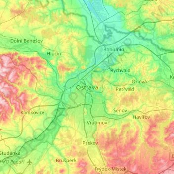
Nombre: Mapa topográfico Ostrau, altitud, relieve.
Altitud media: 258 m
Altitud mínima: 184 m
Altitud máxima: 408 m
Otros mapas topográficos
Haga clic en un mapa para ver su topografía, su altitud y su relieve.
Polanka
Tschechien > Mährisch-Schlesien > Mährisch-Schlesische Region > Ostrau > Polanka
Polanka, Ostrau, Bezirk Ostrau-Stadt, Mährisch-Schlesische Region, Mährisch-Schlesien, 72525, Tschechien
Altitud media: 242 m