
Mapa topográfico Mount Apo
Haga clic en el mapa para ver la altitud.
Mount Apo
Mount Apo is the highest mountain peak in the Philippines, with an elevation of 2,954 meters (9,692 ft) above sea level. A large solfataric, dormant stratovolcano, it is part of the Apo-Talomo Mountain Range of Mindanao island. Apo is situated on the tripartite border of Davao City, Davao del Sur, and Cotabato; its peak is visible from Davao City 45 kilometers (28 mi) to the northeast, Digos 25 kilometers (16 mi) to the southeast, and Bansalan 20 kilometers (12 mi) to the west. Apo is a protected area and is the centerpiece of Mount Apo Natural Park.
Acerca de este mapa
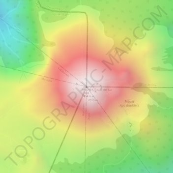
Nombre: Mapa topográfico Mount Apo, altitud, relieve.
Altitud media: 2.419 m
Altitud mínima: 1.815 m
Altitud máxima: 2.931 m