Mapa topográfico Franklin
Haga clic en el mapa para ver la altitud.
Acerca de este mapa
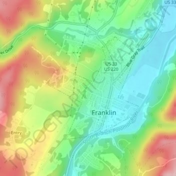
Nombre: Mapa topográfico Franklin, altitud, relieve.
Lugar: Franklin, Pendleton County, West Virginia, United States (38.63874 -79.34229 38.65454 -79.32429)
Altitud media: 586 m
Altitud mínima: 500 m
Altitud máxima: 803 m
Otros mapas topográficos
Haga clic en un mapa para ver su topografía, su altitud y su relieve.

Spruce Knob
United States > West Virginia > Pendleton County
Spruce Mountain, located in eastern West Virginia, is the highest ridge of the Allegheny Mountains. The whale-backed ridge extends for only 16 miles (26 km) from northeast to southwest, but several of its peaks exceed 4,500 feet (1,400 m) in elevation. The summit, Spruce Knob (4,863 ft; 1,482 m), is the…
Altitud media: 1.274 m

Spruce Knob
United States > West Virginia > Pendleton County
Spruce Mountain, located in eastern West Virginia, is the highest ridge of the Allegheny Mountains. The whale-backed ridge extends for only 16 miles (26 km) from northeast to southwest, but several of its peaks exceed 4,500 feet (1,400 m) in elevation. The summit, Spruce Knob (4863 ft; 1482 m), is the highest…
Altitud media: 1.274 m