
Haz una donación
Equípate para tu próxima aventura:
Como asociado de Amazon, este sitio gana comisiones por las compras que califican, sin ningún costo adicional para usted.
Mapa topográfico Mashpee
Haga clic en el mapa para ver la altitud.
Haz una donación
Equípate para tu próxima aventura:
Como asociado de Amazon, este sitio gana comisiones por las compras que califican, sin ningún costo adicional para usted.
Mashpee
Like all towns on the Cape, Mashpee's topography is that of sandy soil, small ponds and inlets, surrounded by the pines and oaks indigenous to the area. The town's shoreline is framed by Waquoit Bay to the west and Popponesset Bay to the east, with several rivers, brooks and small ponds in the area. The town contains South Cape Beach State Park along Dead Neck and Waquoit Bay, and the Lowell Holly Reservation, comprising the land between Wakeby and Mashpee Ponds.
Haz una donación
Equípate para tu próxima aventura:
Como asociado de Amazon, este sitio gana comisiones por las compras que califican, sin ningún costo adicional para usted.
Acerca de este mapa
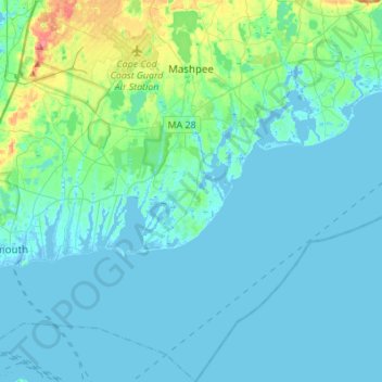
Nombre: Mapa topográfico Mashpee, altitud, relieve.
Altitud media: 10 m
Altitud mínima: -11 m
Altitud máxima: 72 m
Haz una donación
Equípate para tu próxima aventura:
Como asociado de Amazon, este sitio gana comisiones por las compras que califican, sin ningún costo adicional para usted.
Otros mapas topográficos
Haga clic en un mapa para ver su topografía, su altitud y su relieve.
Opeechee Heights Beach
United States > Massachusetts > Barnstable County > Barnstable > Centerville
Altitud media: 14 m
Haz una donación
Equípate para tu próxima aventura:
Como asociado de Amazon, este sitio gana comisiones por las compras que califican, sin ningún costo adicional para usted.
Haz una donación
Equípate para tu próxima aventura:
Como asociado de Amazon, este sitio gana comisiones por las compras que califican, sin ningún costo adicional para usted.
Bourne Corners
United States > Massachusetts > Barnstable County > Bourne > Buzzards Bay
Altitud media: 9 m
Gray Gables
United States > Massachusetts > Barnstable County > Bourne > Buzzards Bay
Altitud media: 5 m
Haz una donación
Equípate para tu próxima aventura:
Como asociado de Amazon, este sitio gana comisiones por las compras que califican, sin ningún costo adicional para usted.
Haz una donación
Equípate para tu próxima aventura:
Como asociado de Amazon, este sitio gana comisiones por las compras que califican, sin ningún costo adicional para usted.
West Barnstable
United States > Massachusetts > Barnstable County > West Barnstable
Altitud media: 15 m
Haz una donación
Equípate para tu próxima aventura:
Como asociado de Amazon, este sitio gana comisiones por las compras que califican, sin ningún costo adicional para usted.
Haz una donación
Equípate para tu próxima aventura:
Como asociado de Amazon, este sitio gana comisiones por las compras que califican, sin ningún costo adicional para usted.
Washburn Island
United States > Massachusetts > Barnstable County > Falmouth > Menauhant
Altitud media: 1 m
Haz una donación
Equípate para tu próxima aventura:
Como asociado de Amazon, este sitio gana comisiones por las compras que califican, sin ningún costo adicional para usted.
Haz una donación
Equípate para tu próxima aventura:
Como asociado de Amazon, este sitio gana comisiones por las compras que califican, sin ningún costo adicional para usted.
Haz una donación
Equípate para tu próxima aventura:
Como asociado de Amazon, este sitio gana comisiones por las compras que califican, sin ningún costo adicional para usted.
Bournedale
United States > Massachusetts > Barnstable County > Bourne > Bournedale
Altitud media: 29 m
Barnstable
United States > Massachusetts > Barnstable County > Barnstable > Barnstable
Altitud media: 10 m
Dennis Port
United States > Massachusetts > Barnstable County > Dennis > Dennis Port
Altitud media: 3 m
Haz una donación
Equípate para tu próxima aventura:
Como asociado de Amazon, este sitio gana comisiones por las compras que califican, sin ningún costo adicional para usted.