
Mapa topográfico Nitra
Mapa interactivo
Haga clic en el mapa para ver la altitud.
Acerca de este mapa
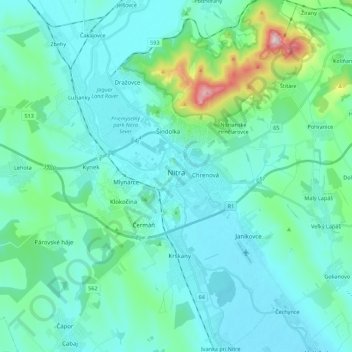
Nombre: Mapa topográfico Nitra, altitud, relieve.
Altitud media: 197 m
Altitud mínima: 129 m
Altitud máxima: 604 m
Nitra lies at an altitude of 190 metres (623 ft) above sea level and covers an area of 100.48 square kilometres (38.8 sq mi). It is located in the Nitra River valley in the Danubian Lowland, where the bigger part of the city is located. A smaller part is located at the southernmost reaches of the Tribeč mountains, more precisely at the foothill of the Zobor mountain 587 metres (1,926 ft). It is around halfway between Slovak capital Bratislava, 92 kilometres (57 mi) away and central Slovak city of Banská Bystrica, 118 kilometres (73 mi) away. Other towns in the surroundings include Trnava to the west (53 km), Topoľčany to the north (35 km), Levice to the east (42 km), and Nové Zámky (37 km) and Komárno (71 km) to the south. A national natural reservation called Zoborská lesostep is located within the city's boundaries.
Otros mapas topográficos
Haga clic en un mapa para ver su topografía, su altitud y su relieve.
Malý Lapáš
Slovakia > Region of Nitra > District of Nitra > Malý Lapáš
Malý Lapáš, District of Nitra, Region of Nitra, Western Slovakia, 95104, Slovakia
Altitud media: 205 m