
Haz una donación
Equípate para tu próxima aventura:
Como asociado de Amazon, este sitio gana comisiones por las compras que califican, sin ningún costo adicional para usted.
Mapa topográfico Plainfield
Haga clic en el mapa para ver la altitud.
Haz una donación
Equípate para tu próxima aventura:
Como asociado de Amazon, este sitio gana comisiones por las compras que califican, sin ningún costo adicional para usted.
Plainfield
Like its namesake, Plainfield's topography is generally flat. Thousands of years ago, land in greater Plainfield used to be part of the bed of proglacial Lake Wauponsee. However, the lake did not hold up long, and eventually drained into the Illinois River valley. The lake left behind a very flat landscape. Much of downtown Plainfield has an elevation of around 600–625 feet (183–191 m) above sea level, with some areas in the western and northwestern portions of the village's outskirts exceeding 700 feet (210 m). This rise in elevation was created by terminal moraines that were formed during the Wisconsin Episode of the last ice age's last glacial period that has been recorded.
Haz una donación
Equípate para tu próxima aventura:
Como asociado de Amazon, este sitio gana comisiones por las compras que califican, sin ningún costo adicional para usted.
Acerca de este mapa
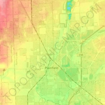
Nombre: Mapa topográfico Plainfield, altitud, relieve.
Altitud media: 194 m
Altitud mínima: 148 m
Altitud máxima: 236 m
Haz una donación
Equípate para tu próxima aventura:
Como asociado de Amazon, este sitio gana comisiones por las compras que califican, sin ningún costo adicional para usted.
Otros mapas topográficos
Haga clic en un mapa para ver su topografía, su altitud y su relieve.
Haz una donación
Equípate para tu próxima aventura:
Como asociado de Amazon, este sitio gana comisiones por las compras que califican, sin ningún costo adicional para usted.