
Haz una donación
Equípate para tu próxima aventura:
Como asociado de Amazon, este sitio gana comisiones por las compras que califican, sin ningún costo adicional para usted.
Mapa topográfico Mountain Grove
Haga clic en el mapa para ver la altitud.
Haz una donación
Equípate para tu próxima aventura:
Como asociado de Amazon, este sitio gana comisiones por las compras que califican, sin ningún costo adicional para usted.
Mountain Grove
This became known as the "mountain store, mountain grove or the mountain" due to its elevation of 1,525 feet (465 m). One of the most famous incidents in Mountain Grove occurred in the middle of May 1883, when what was called a "nipping frost" caused every tree, sapling and shrub in the community of Fyan and the Fyan depot to be cut clean as from an axe. Thus, the joining of Mountain Grove and adjoining Fyan occurred. In June, the name of the depot was changed to Mountain Grove. The town reapplied for a charter in 1886, changed its boundaries and held its first election.
Haz una donación
Equípate para tu próxima aventura:
Como asociado de Amazon, este sitio gana comisiones por las compras que califican, sin ningún costo adicional para usted.
Acerca de este mapa
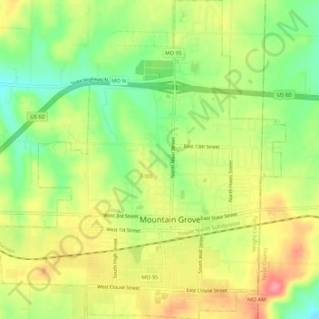
Nombre: Mapa topográfico Mountain Grove, altitud, relieve.
Lugar: Mountain Grove, Wright County, Missouri, United States (37.11790 -92.29495 37.15848 -92.24493)
Altitud media: 444 m
Altitud mínima: 401 m
Altitud máxima: 488 m
Haz una donación
Equípate para tu próxima aventura:
Como asociado de Amazon, este sitio gana comisiones por las compras que califican, sin ningún costo adicional para usted.