
Mapa topográfico Bernville
Mapa interactivo
Haga clic en el mapa para ver la altitud.
Acerca de este mapa
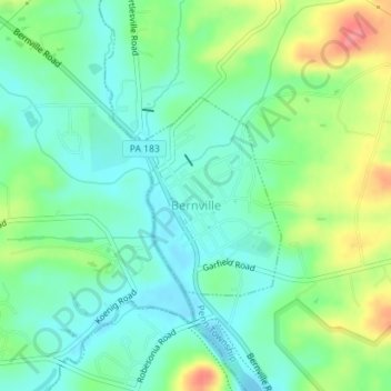
Nombre: Mapa topográfico Bernville, altitud, relieve.
Lugar: Bernville, Berks County, Pennsylvania, United States (40.42719 -76.11685 40.44091 -76.10441)
Altitud media: 113 m
Altitud mínima: 87 m
Altitud máxima: 168 m
Northkill Creek feeds into Blue Marsh Lake, and the Blue Marsh slackwater is federal property. Hence a portion of Bernville is part of the Blue Marsh system. Blue Marsh Lake is a popular recreation site, offering hiking, boating, and fishing. The lake is also important for water supply, flood control, and wildlife habitat. A levee along Northkill Creek protects Bernville from Blue Marsh flooding above 300 feet (91 m) elevation.
Otros mapas topográficos
Haga clic en un mapa para ver su topografía, su altitud y su relieve.
Topton
United States > Pennsylvania > Berks County
Topton, Berks County, Pennsylvania, United States
Altitud media: 161 m
Alsace Township
United States > Pennsylvania > Berks County
Alsace Township, Berks County, Pennsylvania, United States
Altitud media: 231 m
Blue Mountain
United States > Pennsylvania > Berks County > Bethel Township
Blue Mountain, Bethel Township, Berks County, Pennsylvania, 19549, United States
Altitud media: 227 m
Dale
United States > Pennsylvania > Berks County > Washington Township > Dale
Dale, Washington Township, Berks County, Pennsylvania, 19503, United States
Altitud media: 236 m
Reading
United States > Pennsylvania > Berks County
Reading, Berks County, Pennsylvania, United States
Altitud media: 116 m