
Haz una donación
Equípate para tu próxima aventura:
Como asociado de Amazon, este sitio gana comisiones por las compras que califican, sin ningún costo adicional para usted.
Mapa topográfico Richloam
Haga clic en el mapa para ver la altitud.
Haz una donación
Equípate para tu próxima aventura:
Como asociado de Amazon, este sitio gana comisiones por las compras que califican, sin ningún costo adicional para usted.
Acerca de este mapa
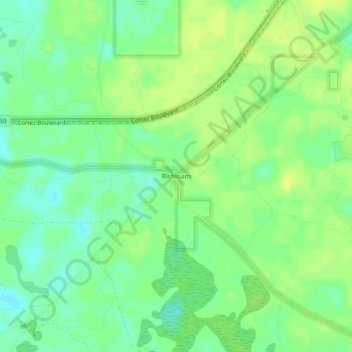
Nombre: Mapa topográfico Richloam, altitud, relieve.
Lugar: Richloam, Hernando County, Florida, United States (28.48139 -82.13286 28.52139 -82.09286)
Altitud media: 25 m
Altitud mínima: 15 m
Altitud máxima: 31 m
Haz una donación
Equípate para tu próxima aventura:
Como asociado de Amazon, este sitio gana comisiones por las compras que califican, sin ningún costo adicional para usted.
Otros mapas topográficos
Haga clic en un mapa para ver su topografía, su altitud y su relieve.
Brooksville
United States > Florida > Hernando County
Brooksville is known for its rolling topography with elevations ranging from 100 ft to 180 ft. The highest elevation in the area is Chinsegut Hill, at 269 ft, over five and a half miles north of the city.
Altitud media: 29 m
Brooksville
United States > Florida > Hernando County
Brooksville is known for its rolling topography with elevations ranging from 100 ft to 180 ft. The highest elevation in the area is Chinsegut Hill, at 269 ft, over five and a half miles north of the city.
Altitud media: 38 m
Weeki Wachee
United States > Florida > Hernando County
Weeki Wachee features a unique and diverse topography characterized primarily by its proximity to the Weeki Wachee River and the surrounding Weeki Wachee Preserve. The area sits at a low elevation of about 33 feet above sea level, encompassing approximately 1.05 square miles, with a landscape that blends…
Altitud media: 11 m
Haz una donación
Equípate para tu próxima aventura:
Como asociado de Amazon, este sitio gana comisiones por las compras que califican, sin ningún costo adicional para usted.
Spring Lake
United States > Florida > Hernando County
Spring Lake contains rolling hills ranging in elevation from 120ft to 280ft.
Altitud media: 49 m
Haz una donación
Equípate para tu próxima aventura:
Como asociado de Amazon, este sitio gana comisiones por las compras que califican, sin ningún costo adicional para usted.
Haz una donación
Equípate para tu próxima aventura:
Como asociado de Amazon, este sitio gana comisiones por las compras que califican, sin ningún costo adicional para usted.
Haz una donación
Equípate para tu próxima aventura:
Como asociado de Amazon, este sitio gana comisiones por las compras que califican, sin ningún costo adicional para usted.
Spring Lake
United States > Florida > Hernando County > Spring Lake
Spring Lake contains rolling hills ranging in elevation from 120ft to 280ft.
Altitud media: 49 m
Brooksville
United States > Florida > Hernando County
Brooksville is known for its rolling topography with elevations ranging from 100 ft to 180 ft. The highest elevation in the area is Chinsegut Hill, at 269 ft, over five and a half miles north of the city.
Altitud media: 38 m
Spring Lake
United States > Florida > Hernando County
Spring Lake contains rolling hills ranging in elevation from 120ft to 280ft.
Altitud media: 49 m
Haz una donación
Equípate para tu próxima aventura:
Como asociado de Amazon, este sitio gana comisiones por las compras que califican, sin ningún costo adicional para usted.