
Mapa topográfico Deer Horn Island
Mapa interactivo
Haga clic en el mapa para ver la altitud.
Acerca de este mapa
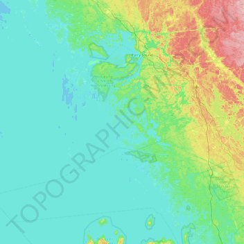
Nombre: Mapa topográfico Deer Horn Island, altitud, relieve.
Altitud media: 199 m
Altitud mínima: 172 m
Altitud máxima: 328 m
Otros mapas topográficos
Haga clic en un mapa para ver su topografía, su altitud y su relieve.
Pointe au Baril
Canada > Ontario > Parry Sound District > The Archipelago Township
Pointe au Baril, The Archipelago Township, Parry Sound District, Central Ontario, Ontario, Canada
Altitud media: 177 m
Conger Lake
Canada > Ontario > Parry Sound District > The Archipelago Township
Conger Lake, The Archipelago Township, Parry Sound District, Central Ontario, Ontario, Canada
Altitud media: 200 m
Moon River
Canada > Ontario > Parry Sound District > The Archipelago Township
Moon River, The Archipelago Township, Parry Sound District, Central Ontario, Ontario, Canada
Altitud media: 185 m
Moon River
Canada > Ontario > Parry Sound District > The Archipelago Township
Moon River, The Archipelago Township, Parry Sound District, Central Ontario, Ontario, Canada
Altitud media: 185 m
Watt Island
Canada > Ontario > Parry Sound District > The Archipelago Township
Watt Island, The Archipelago Township, Parry Sound District, Central Ontario, Ontario, Canada
Altitud media: 195 m