
Mapa topográfico Golaghat
Mapa interactivo
Haga clic en el mapa para ver la altitud.
Acerca de este mapa
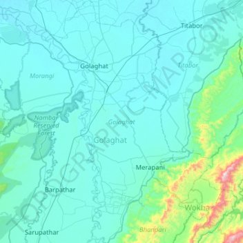
Nombre: Mapa topográfico Golaghat, altitud, relieve.
Lugar: Golaghat, Assam, India (26.17458 93.87096 26.63430 94.17736)
Altitud media: 168 m
Altitud mínima: 82 m
Altitud máxima: 1.212 m
Otros mapas topográficos
Haga clic en un mapa para ver su topografía, su altitud y su relieve.
Jorhat
India > Assam > Jorhat East
Jorhat, Jorhat East, Jorhat District, Assam, 785001, India
Altitud media: 93 m
Kaziranga National Park and Tiger Reserve
Kaziranga National Park and Tiger Reserve, Bokakhat, Golaghat District, Assam, India
Altitud media: 202 m
Numaligarh
India > Assam > Bokakhat > Numaligarh
Numaligarh, Bokakhat, Golaghat, Assam, 785615, India
Altitud media: 87 m
Mahatma Gandhi Park
Mahatma Gandhi Park, Chowk Bazar, Atila Gaon, Jorhat, Assam, India
Altitud media: 92 m