
Mapa topográfico Staincross
Haga clic en el mapa para ver la altitud.
Staincross
Staincross lies off the A61 road, about three miles north-west of Barnsley. It is located at approximately 53°35′27″N 1°30′0″W / 53.59083°N 1.50000°W / 53.59083; -1.50000, and at an elevation of around 410 feet (125 m) above sea level. The section of the A61 between Staincross and Newmillerdam is rated in the top three most dangerous roads in Britain according to a survey conducted by The AA Motoring Trust.
Acerca de este mapa
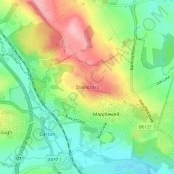
Nombre: Mapa topográfico Staincross, altitud, relieve.
Altitud media: 94 m
Altitud mínima: 46 m
Altitud máxima: 173 m
Otros mapas topográficos
Haga clic en un mapa para ver su topografía, su altitud y su relieve.
Shafton
United Kingdom > England > Barnsley
Shafton lies to the north of Shafton Two Gates, on the road to Ryhill. It is located at approximately 53° 35' 10" North, 1° 24' West, at an elevation of around 262 feet (80 m) above sea level. Sceptun in the Domesday Book of 1086 then later in c. 1160 Scaftona meaning a farmstead marked by a pole, or made…
Altitud media: 65 m
High Hoyland
United Kingdom > England > Barnsley
High Hoyland is a village and civil parish in the Metropolitan Borough of Barnsley in South Yorkshire, England, on the border with West Yorkshire. It lies to the west of Kexbrough, and is located at approximately 53°35′10″N 1°35′30″W / 53.58611°N 1.59167°W / 53.58611; -1.59167, at an…
Altitud media: 139 m