
Mapa topográfico Trevi
Mapa interactivo
Haga clic en el mapa para ver la altitud.
Acerca de este mapa
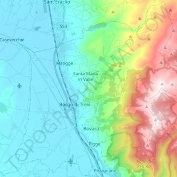
Nombre: Mapa topográfico Trevi, altitud, relieve.
Lugar: Trevi, Perugia, Umbria, 06039, Italy (42.83403 12.69013 42.93376 12.82816)
Altitud media: 507 m
Altitud mínima: 200 m
Altitud máxima: 1.418 m
The natural environment of the territory as a whole remains largely unspoiled, this despite being significantly populated for millennia. The mountainous area is now witnessing a considerable depopulation — as elsewhere in Italy, in the second half of the 20th century settlements at the highest elevations have been rapidly losing their inhabitants to the plains. The most important growth areas since the period following World War II have been Borgo Trevi (commercial, residential, and offices), Pietrarossa (industrial), and Matigge (light and medium industry, commercial).
Otros mapas topográficos
Haga clic en un mapa para ver su topografía, su altitud y su relieve.
San Pietro
Italy > Umbria > Perugia > Corciano
San Pietro, Corciano, Perugia, Umbria, 06073, Italy
Altitud media: 264 m
San Giorgio
Italy > Umbria > Perugia > Cascia
San Giorgio, Cascia, Perugia, Umbria, 06043, Italy
Altitud media: 786 m
Fratticiola Selvatica
Italy > Umbria > Perugia > Perugia
Fratticiola Selvatica, Perugia, Umbria, Italy
Altitud media: 503 m
Città di Castello
Italy > Umbria > Perugia > Città di Castello
Città di Castello, Perugia, Umbria, Italy
Altitud media: 504 m
Giano dell'Umbria
Italy > Umbria > Perugia > Giano dell'Umbria
Giano dell'Umbria, Perugia, Umbria, 06030, Italy
Altitud media: 470 m
Compignano
Italy > Umbria > Perugia > Marsciano
Compignano, Marsciano, Perugia, Umbria, 06055, Italy
Altitud media: 234 m