
Mapa topográfico Brookfield
Mapa interactivo
Haga clic en el mapa para ver la altitud.
Acerca de este mapa
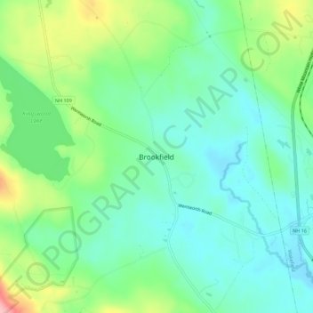
Nombre: Mapa topográfico Brookfield, altitud, relieve.
Altitud media: 195 m
Altitud mínima: 152 m
Altitud máxima: 296 m
According to the United States Census Bureau, the town has a total area of 23.2 square miles (60.2 km2), of which 22.8 sq mi (59.1 km2) are land and 0.42 sq mi (1.1 km2) are water, comprising 1.82% of the town.[1] Brookfield is drained primarily by the Branch River and Pike Brook, within the Piscataqua River (coastal) watershed, though the western edge of the town is in the Merrimack River watershed and the northernmost tip of the town is in the Saco River watershed.[5] Copple Crown Mountain, along the western border of Brookfield and the highest point in town, has an elevation of 1,868 feet (569 m) above sea level.